You are here: Home > Network List > KO - Kandilli Observatory Digital Broadband Seismic Network Stations List
> Station SIRT Sirnak-Turkey > Earthquake Result Viewer
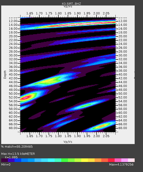
SIRT Sirnak-Turkey - Earthquake Result Viewer
| Earthquake location: |
Nepal |
| Earthquake latitude/longitude: |
28.2/84.7 |
| Earthquake time(UTC): |
2015/04/25 (115) 06:11:25 GMT |
| Earthquake Depth: |
12 km |
| Earthquake Magnitude: |
7.5 MWB |
| Earthquake Catalog/Contributor: |
NEIC PDE/NEIC COMCAT |
|
| Network: |
KO Kandilli Observatory Digital Broadband Seismic Network |
| Station: |
SIRT Sirnak-Turkey |
| Lat/Lon: |
37.50 N/42.44 E |
| Elevation: |
1038 m |
|
| Distance: |
36.5 deg |
| Az: |
295.823 deg |
| Baz: |
92.17 deg |
| Ray Param: |
0.07665593 |
| Estimated Moho Depth: |
13.5 km |
| Estimated Crust Vp/Vs: |
1.89 |
| Assumed Crust Vp: |
6.482 km/s |
| Estimated Crust Vs: |
3.421 km/s |
| Estimated Crust Poisson's Ratio: |
0.31 |
|
| Radial Match: |
88.209465 % |
| Radial Bump: |
400 |
| Transverse Match: |
82.49084 % |
| Transverse Bump: |
400 |
| SOD ConfigId: |
7422571 |
| Insert Time: |
2019-04-18 08:37:46.411 +0000 |
| GWidth: |
2.5 |
| Max Bumps: |
400 |
| Tol: |
0.001 |
|

Signal To Noise
| Channel | StoN | STA | LTA |
| KO:SIRT: :BHZ:20150425T06:18:00.499993Z | 1.8068752 | 1.07538945E-5 | 5.951653E-6 |
| KO:SIRT: :BHN:20150425T06:18:00.499993Z | 0.7946591 | 1.1851653E-6 | 1.4914134E-6 |
| KO:SIRT: :BHE:20150425T06:18:00.499993Z | 7.3935223 | 3.577399E-6 | 4.8385584E-7 |
| Arrivals |
| Ps | 2.0 SECOND |
| PpPs | 5.6 SECOND |
| PsPs/PpSs | 7.6 SECOND |


