You are here: Home > Network List > PF - Volcanologic Network of Piton de Fournaise-OVPF Stations List
> Station GPS Grandes Pentes Sud > Earthquake Result Viewer
GPS Grandes Pentes Sud - Earthquake Result Viewer
| Earthquake location: |
Nepal |
| Earthquake latitude/longitude: |
28.2/84.7 |
| Earthquake time(UTC): |
2015/04/25 (115) 06:11:25 GMT |
| Earthquake Depth: |
12 km |
| Earthquake Magnitude: |
7.5 MWB |
| Earthquake Catalog/Contributor: |
NEIC PDE/NEIC COMCAT |
|
| Network: |
PF Volcanologic Network of Piton de Fournaise-OVPF |
| Station: |
GPS Grandes Pentes Sud |
| Lat/Lon: |
21.27 S/55.76 E |
| Elevation: |
1004 m |
|
| Distance: |
56.6 deg |
| Az: |
212.773 deg |
| Baz: |
30.824 deg |
| Ray Param: |
0.06406304 |
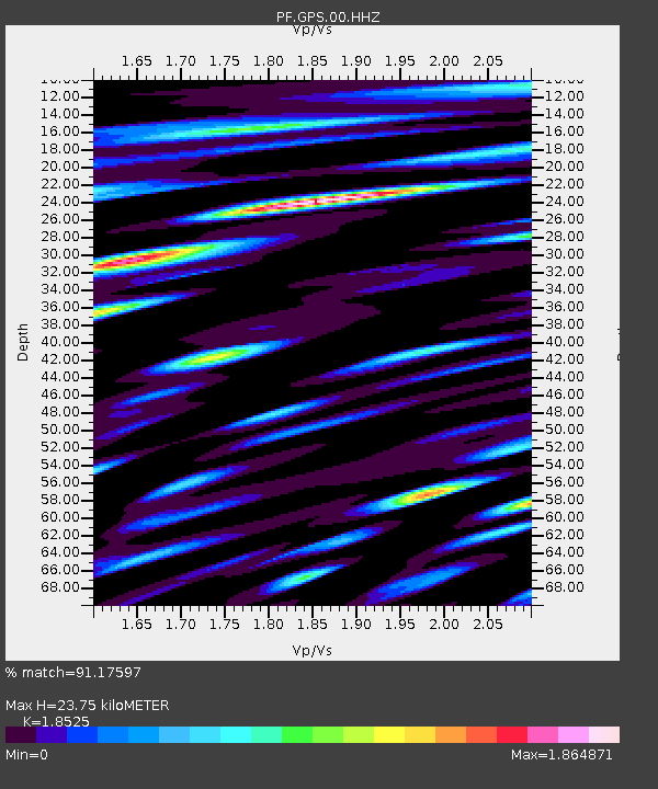
| Estimated Moho Depth: |
23.75 km |
| Estimated Crust Vp/Vs: |
1.85 |
| Assumed Crust Vp: |
4.73 km/s |
| Estimated Crust Vs: |
2.553 km/s |
| Estimated Crust Poisson's Ratio: |
0.29 |
|
| Radial Match: |
91.17597 % |
| Radial Bump: |
400 |
| Transverse Match: |
82.00107 % |
| Transverse Bump: |
400 |
| SOD ConfigId: |
7422571 |
| Insert Time: |
2019-04-18 08:38:10.416 +0000 |
| GWidth: |
2.5 |
| Max Bumps: |
400 |
| Tol: |
0.001 |
|
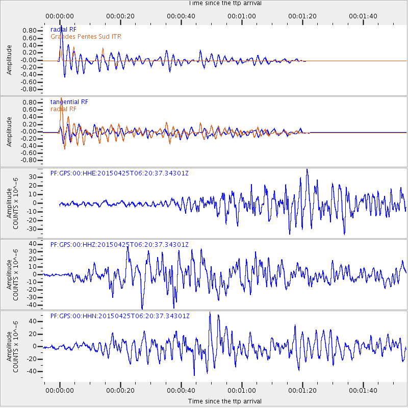
Signal To Noise
| Channel | StoN | STA | LTA |
| PF:GPS:00:HHZ:20150425T06:20:37.34301Z | 3.2639437 | 2.6574364E-6 | 8.1417966E-7 |
| PF:GPS:00:HHN:20150425T06:20:37.34301Z | 1.1694549 | 2.2883135E-6 | 1.9567349E-6 |
| PF:GPS:00:HHE:20150425T06:20:37.34301Z | 1.0963485 | 1.8098539E-6 | 1.6508016E-6 |
| Arrivals |
| Ps | 4.4 SECOND |
| PpPs | 14 SECOND |
| PsPs/PpSs | 18 SECOND |


