You are here: Home > Network List > YB13 - Continental Dynamics/Cent. Anatolian Tectonics:Surface to Mantle Dynamics During Stations List
> Station AT20 Kirkpinar,Kersehir,Turkey > Earthquake Result Viewer
AT20 Kirkpinar,Kersehir,Turkey - Earthquake Result Viewer
| Earthquake location: |
Nepal |
| Earthquake latitude/longitude: |
28.2/84.7 |
| Earthquake time(UTC): |
2015/04/25 (115) 06:11:25 GMT |
| Earthquake Depth: |
12 km |
| Earthquake Magnitude: |
7.5 MWB |
| Earthquake Catalog/Contributor: |
NEIC PDE/NEIC COMCAT |
|
| Network: |
YB Continental Dynamics/Cent. Anatolian Tectonics:Surface to Mantle Dynamics During |
| Station: |
AT20 Kirkpinar,Kersehir,Turkey |
| Lat/Lon: |
39.36 N/34.16 E |
| Elevation: |
1235 m |
|
| Distance: |
43.0 deg |
| Az: |
298.605 deg |
| Baz: |
89.18 deg |
| Ray Param: |
0.07282723 |
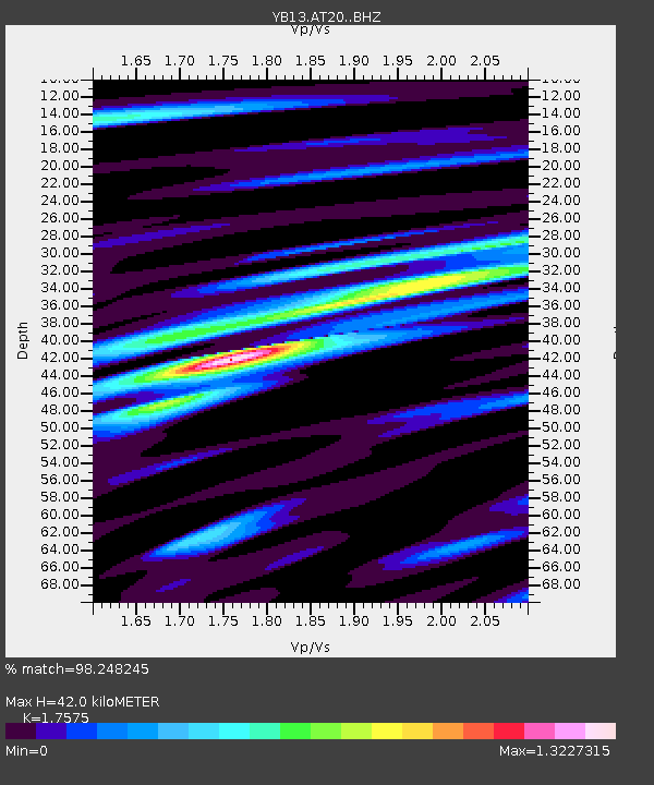
| Estimated Moho Depth: |
42.0 km |
| Estimated Crust Vp/Vs: |
1.76 |
| Assumed Crust Vp: |
6.35 km/s |
| Estimated Crust Vs: |
3.613 km/s |
| Estimated Crust Poisson's Ratio: |
0.26 |
|
| Radial Match: |
98.248245 % |
| Radial Bump: |
360 |
| Transverse Match: |
93.381096 % |
| Transverse Bump: |
400 |
| SOD ConfigId: |
7422571 |
| Insert Time: |
2019-04-18 08:39:10.351 +0000 |
| GWidth: |
2.5 |
| Max Bumps: |
400 |
| Tol: |
0.001 |
|

Signal To Noise
| Channel | StoN | STA | LTA |
| YB:AT20: :BHZ:20150425T06:18:54.719994Z | 32.157753 | 2.8051188E-6 | 8.7229935E-8 |
| YB:AT20: :BHN:20150425T06:18:54.719994Z | 4.353049 | 3.186252E-7 | 7.319587E-8 |
| YB:AT20: :BHE:20150425T06:18:54.719994Z | 22.433695 | 1.5399721E-6 | 6.86455E-8 |
| Arrivals |
| Ps | 5.4 SECOND |
| PpPs | 17 SECOND |
| PsPs/PpSs | 22 SECOND |


