You are here: Home > Network List > TA - USArray Transportable Network (new EarthScope stations) Stations List
> Station J01E Myrtle Point, OR, USA > Earthquake Result Viewer
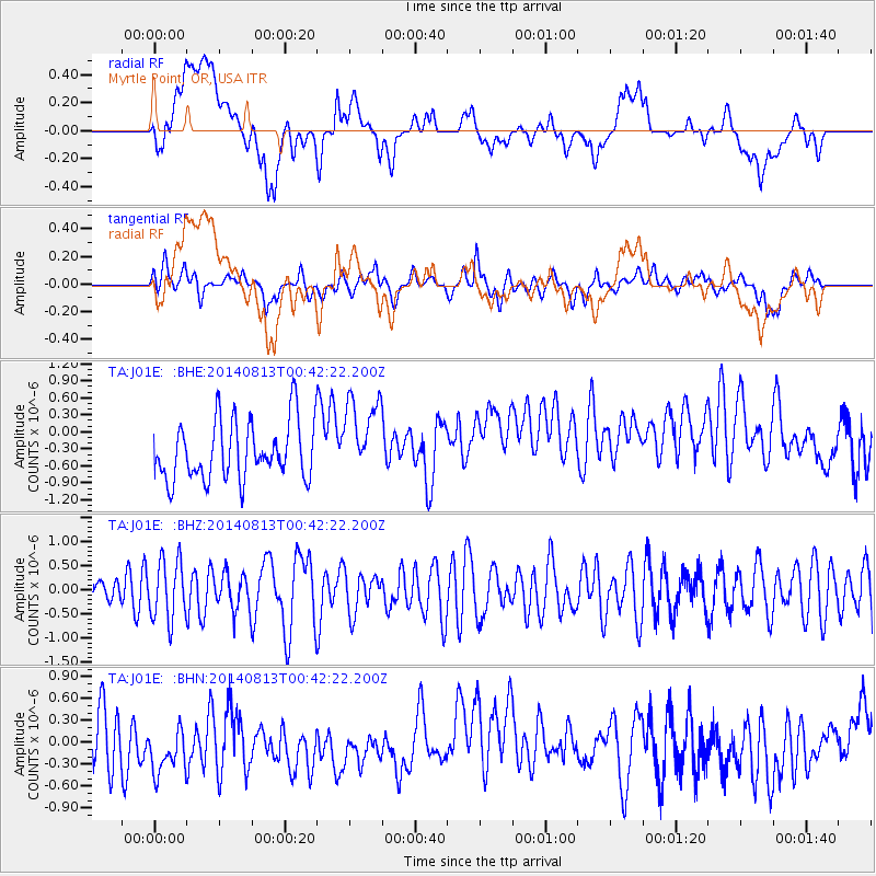
J01E Myrtle Point, OR, USA - Earthquake Result Viewer
*The percent match for this event was below the threshold and hence no stack was calculated.
| Earthquake location: |
Mariana Islands |
| Earthquake latitude/longitude: |
13.9/145.0 |
| Earthquake time(UTC): |
2014/08/13 (225) 00:30:47 GMT |
| Earthquake Depth: |
98 km |
| Earthquake Magnitude: |
5.6 MWW, 5.6 MWC, 5.6 MWB |
| Earthquake Catalog/Contributor: |
NEIC PDE/NEIC COMCAT |
|
| Network: |
TA USArray Transportable Network (new EarthScope stations) |
| Station: |
J01E Myrtle Point, OR, USA |
| Lat/Lon: |
43.16 N/123.93 W |
| Elevation: |
128 m |
|
| Distance: |
81.4 deg |
| Az: |
47.722 deg |
| Baz: |
280.925 deg |
| Ray Param: |
$rayparam |
*The percent match for this event was below the threshold and hence was not used in the summary stack. |
|
| Radial Match: |
13.758809 % |
| Radial Bump: |
400 |
| Transverse Match: |
41.49325 % |
| Transverse Bump: |
400 |
| SOD ConfigId: |
769524 |
| Insert Time: |
2014-09-17 05:45:41.957 +0000 |
| GWidth: |
2.5 |
| Max Bumps: |
400 |
| Tol: |
0.001 |
|
Signal To Noise
| Channel | StoN | STA | LTA |
| TA:J01E: :BHZ:20140813T00:42:22.200Z | 1.7053672 | 6.14424E-7 | 3.6028837E-7 |
| TA:J01E: :BHN:20140813T00:42:22.200Z | 1.4403471 | 6.0521603E-7 | 4.2018763E-7 |
| TA:J01E: :BHE:20140813T00:42:22.200Z | 1.425228 | 7.288519E-7 | 5.113932E-7 |
| Arrivals |
| Ps | |
| PpPs | |
| PsPs/PpSs | |


