You are here: Home > Network List > YQ13 - Study of Extension and Magmatism in Malawi and Tanzania Stations List
> Station MFRI Mfriga,Tanzania > Earthquake Result Viewer
MFRI Mfriga,Tanzania - Earthquake Result Viewer
| Earthquake location: |
Nepal |
| Earthquake latitude/longitude: |
28.2/84.7 |
| Earthquake time(UTC): |
2015/04/25 (115) 06:11:25 GMT |
| Earthquake Depth: |
12 km |
| Earthquake Magnitude: |
7.5 MWB |
| Earthquake Catalog/Contributor: |
NEIC PDE/NEIC COMCAT |
|
| Network: |
YQ Study of Extension and Magmatism in Malawi and Tanzania |
| Station: |
MFRI Mfriga,Tanzania |
| Lat/Lon: |
9.29 S/35.31 E |
| Elevation: |
1604 m |
|
| Distance: |
60.6 deg |
| Az: |
239.405 deg |
| Baz: |
50.351 deg |
| Ray Param: |
0.061453138 |
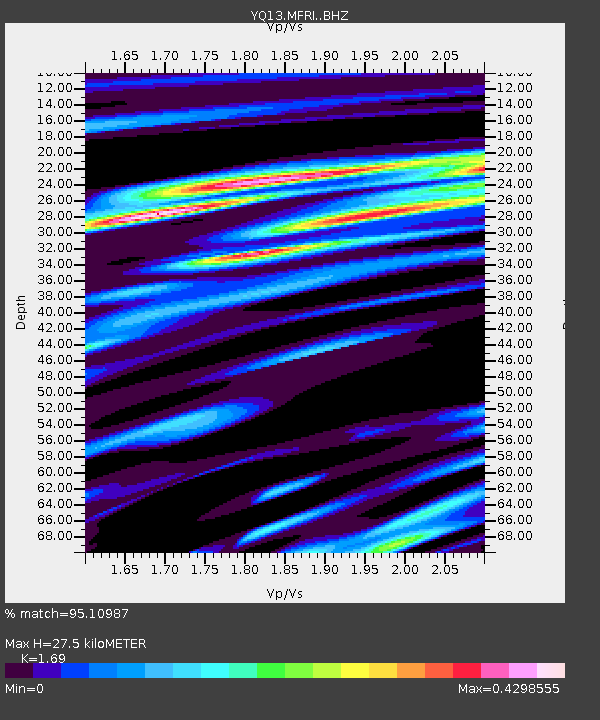
| Estimated Moho Depth: |
27.5 km |
| Estimated Crust Vp/Vs: |
1.69 |
| Assumed Crust Vp: |
6.576 km/s |
| Estimated Crust Vs: |
3.891 km/s |
| Estimated Crust Poisson's Ratio: |
0.23 |
|
| Radial Match: |
95.10987 % |
| Radial Bump: |
335 |
| Transverse Match: |
86.05679 % |
| Transverse Bump: |
400 |
| SOD ConfigId: |
7422571 |
| Insert Time: |
2019-04-18 08:39:49.486 +0000 |
| GWidth: |
2.5 |
| Max Bumps: |
400 |
| Tol: |
0.001 |
|

Signal To Noise
| Channel | StoN | STA | LTA |
| YQ:MFRI: :BHZ:20150425T06:21:05.239983Z | 5.352388 | 8.9473787E-7 | 1.6716612E-7 |
| YQ:MFRI: :BHN:20150425T06:21:05.239983Z | 2.4411683 | 3.2089827E-7 | 1.3145275E-7 |
| YQ:MFRI: :BHE:20150425T06:21:05.239983Z | 2.203807 | 3.3078962E-7 | 1.5009917E-7 |
| Arrivals |
| Ps | 3.0 SECOND |
| PpPs | 11 SECOND |
| PsPs/PpSs | 14 SECOND |


