You are here: Home > Network List > TA - USArray Transportable Network (new EarthScope stations) Stations List
> Station 833A Chaparral WMA, Artesia Wells, TX, USA > Earthquake Result Viewer
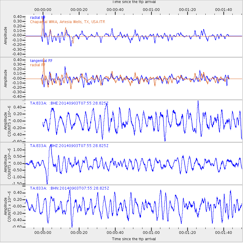
833A Chaparral WMA, Artesia Wells, TX, USA - Earthquake Result Viewer
*The percent match for this event was below the threshold and hence no stack was calculated.
| Earthquake location: |
Tonga Islands |
| Earthquake latitude/longitude: |
-15.0/-173.5 |
| Earthquake time(UTC): |
2014/09/03 (246) 07:43:31 GMT |
| Earthquake Depth: |
10 km |
| Earthquake Magnitude: |
5.7 MB |
| Earthquake Catalog/Contributor: |
NEIC PDE/NEIC COMCAT |
|
| Network: |
TA USArray Transportable Network (new EarthScope stations) |
| Station: |
833A Chaparral WMA, Artesia Wells, TX, USA |
| Lat/Lon: |
28.32 N/99.39 W |
| Elevation: |
171 m |
|
| Distance: |
83.6 deg |
| Az: |
58.572 deg |
| Baz: |
249.277 deg |
| Ray Param: |
$rayparam |
*The percent match for this event was below the threshold and hence was not used in the summary stack. |
|
| Radial Match: |
64.28371 % |
| Radial Bump: |
400 |
| Transverse Match: |
61.709965 % |
| Transverse Bump: |
400 |
| SOD ConfigId: |
769524 |
| Insert Time: |
2014-09-17 08:56:27.601 +0000 |
| GWidth: |
2.5 |
| Max Bumps: |
400 |
| Tol: |
0.001 |
|
Signal To Noise
| Channel | StoN | STA | LTA |
| TA:833A: :BHZ:20140903T07:55:28.825Z | 5.07115 | 8.2101474E-7 | 1.6189912E-7 |
| TA:833A: :BHN:20140903T07:55:28.825Z | 1.6789924 | 2.406968E-7 | 1.4335788E-7 |
| TA:833A: :BHE:20140903T07:55:28.825Z | 1.4949814 | 2.651676E-7 | 1.7737185E-7 |
| Arrivals |
| Ps | |
| PpPs | |
| PsPs/PpSs | |


