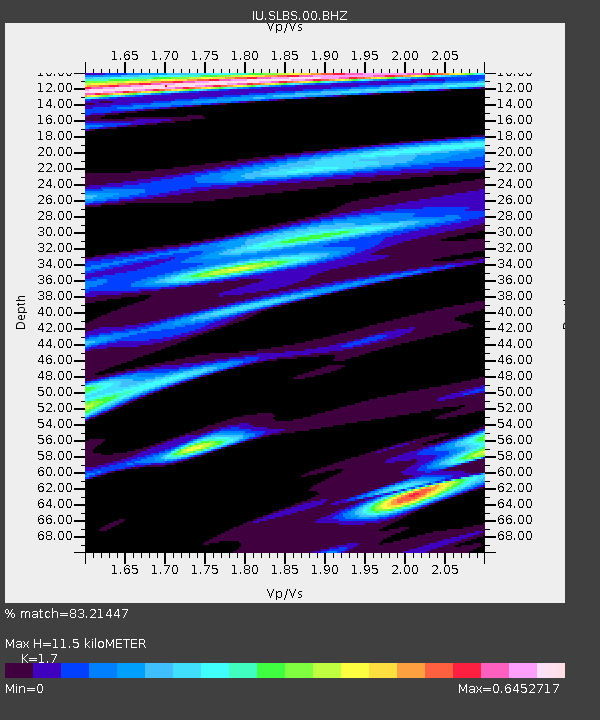
SLBS Sierra la Laguna Baja California Sur, Mexico - Earthquake Result Viewer

Earthquake location: Southeast Of Loyalty Islands
Earthquake latitude/longitude: -22.4/170.6
Earthquake time(UTC): 2009/01/15 (015) 07:27:20 GMT
Earthquake Depth: 27 km
Earthquake Magnitude: 5.8 MB, 6.5 MS, 6.7 MW, 6.6 MW
Earthquake Catalog/Contributor: WHDF/NEIC
Network: IU Global Seismograph Network (GSN - IRIS/USGS)
Station: SLBS Sierra la Laguna Baja California Sur, Mexico
Lat/Lon: 23.69 N/109.94 W
Elevation: 825 m
Distance: 89.7 deg
Az: 64.313 deg
Baz: 245.51 deg
Ray Param: 0.04172124
Estimated Moho Depth: 11.5 km
Estimated Crust Vp/Vs: 1.70
Assumed Crust Vp: 6.183 km/s
Estimated Crust Vs: 3.637 km/s
Estimated Crust Poisson's Ratio: 0.24
Radial Match: 83.21447 %
Radial Bump: 400
Transverse Match: 77.31354 %
Transverse Bump: 400
SOD ConfigId: 2658
Insert Time: 2010-03-02 01:21:04.443 +0000
GWidth: 2.5
Max Bumps: 400
Tol: 0.001

Signal To Noise

ChannelStoNSTALTA
IU:SLBS:00:BHZ:20090115T07:39:44.620017Z6.32779849.564175E-71.5114539E-7
IU:SLBS:00:BHN:20090115T07:39:44.620017Z0.623371541.1037945E-71.7706849E-7
IU:SLBS:00:BHE:20090115T07:39:44.620017Z1.87302653.8601812E-72.0609325E-7
Arrivals
Ps1.3 SECOND
PpPs4.9 SECOND
PsPs/PpSs6.3 SECOND