You are here: Home > Network List > TA - USArray Transportable Network (new EarthScope stations) Stations List
> Station X43A Marvell, AR, USA > Earthquake Result Viewer
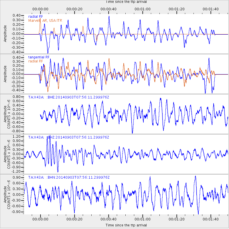
X43A Marvell, AR, USA - Earthquake Result Viewer
*The percent match for this event was below the threshold and hence no stack was calculated.
| Earthquake location: |
Tonga Islands |
| Earthquake latitude/longitude: |
-15.0/-173.5 |
| Earthquake time(UTC): |
2014/09/03 (246) 07:43:31 GMT |
| Earthquake Depth: |
10 km |
| Earthquake Magnitude: |
5.7 MB |
| Earthquake Catalog/Contributor: |
NEIC PDE/NEIC COMCAT |
|
| Network: |
TA USArray Transportable Network (new EarthScope stations) |
| Station: |
X43A Marvell, AR, USA |
| Lat/Lon: |
34.52 N/90.88 W |
| Elevation: |
53 m |
|
| Distance: |
92.5 deg |
| Az: |
55.05 deg |
| Baz: |
253.583 deg |
| Ray Param: |
$rayparam |
*The percent match for this event was below the threshold and hence was not used in the summary stack. |
|
| Radial Match: |
62.468567 % |
| Radial Bump: |
370 |
| Transverse Match: |
52.170387 % |
| Transverse Bump: |
373 |
| SOD ConfigId: |
769524 |
| Insert Time: |
2014-09-17 09:00:59.241 +0000 |
| GWidth: |
2.5 |
| Max Bumps: |
400 |
| Tol: |
0.001 |
|
Signal To Noise
| Channel | StoN | STA | LTA |
| TA:X43A: :BHZ:20140903T07:56:11.299976Z | 3.0563738 | 4.6898506E-7 | 1.5344493E-7 |
| TA:X43A: :BHN:20140903T07:56:11.299976Z | 0.46415186 | 2.3404633E-7 | 5.042451E-7 |
| TA:X43A: :BHE:20140903T07:56:11.299976Z | 1.4845657 | 3.3326805E-7 | 2.2448859E-7 |
| Arrivals |
| Ps | |
| PpPs | |
| PsPs/PpSs | |


