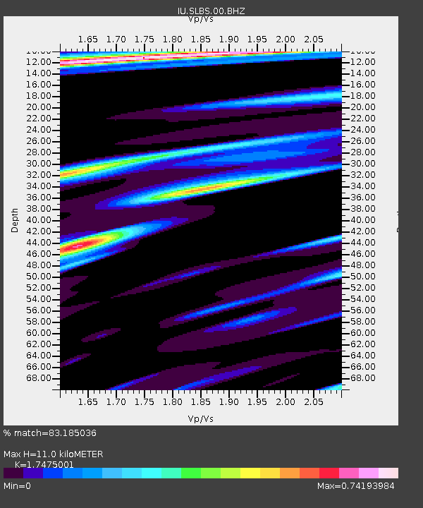
SLBS Sierra la Laguna Baja California Sur, Mexico - Earthquake Result Viewer
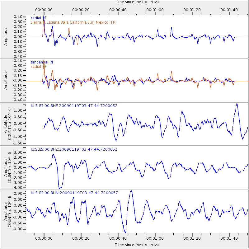
Earthquake location: Southeast Of Loyalty Islands
Earthquake latitude/longitude: -22.6/170.9
Earthquake time(UTC): 2009/01/19 (019) 03:35:18 GMT
Earthquake Depth: 12 km
Earthquake Magnitude: 5.7 MB, 6.4 MS, 6.5 MW, 6.5 MW
Earthquake Catalog/Contributor: WHDF/NEIC
Network: IU Global Seismograph Network (GSN - IRIS/USGS)
Station: SLBS Sierra la Laguna Baja California Sur, Mexico
Lat/Lon: 23.69 N/109.94 W
Elevation: 825 m
Distance: 89.6 deg
Az: 64.206 deg
Baz: 245.18 deg
Ray Param: 0.04173268
Estimated Moho Depth: 11.0 km
Estimated Crust Vp/Vs: 1.75
Assumed Crust Vp: 6.183 km/s
Estimated Crust Vs: 3.538 km/s
Estimated Crust Poisson's Ratio: 0.26
Radial Match: 83.185036 %
Radial Bump: 400
Transverse Match: 82.60944 %
Transverse Bump: 400
SOD ConfigId: 2658
Insert Time: 2010-03-02 01:21:10.397 +0000
GWidth: 2.5
Max Bumps: 400
Tol: 0.001

Signal To Noise

ChannelStoNSTALTA
IU:SLBS:00:BHZ:20090119T03:47:44.720005Z2.72731548.3070125E-73.045857E-7
IU:SLBS:00:BHN:20090119T03:47:44.720005Z0.97429541.8915189E-71.9414225E-7
IU:SLBS:00:BHE:20090119T03:47:44.720005Z0.75762111.915613E-72.5284578E-7
Arrivals
Ps1.4 SECOND
PpPs4.8 SECOND
PsPs/PpSs6.2 SECOND