You are here: Home > Network List > IU - Global Seismograph Network (GSN - IRIS/USGS) Stations List
> Station SLBS Sierra la Laguna Baja California Sur, Mexico > Earthquake Result Viewer
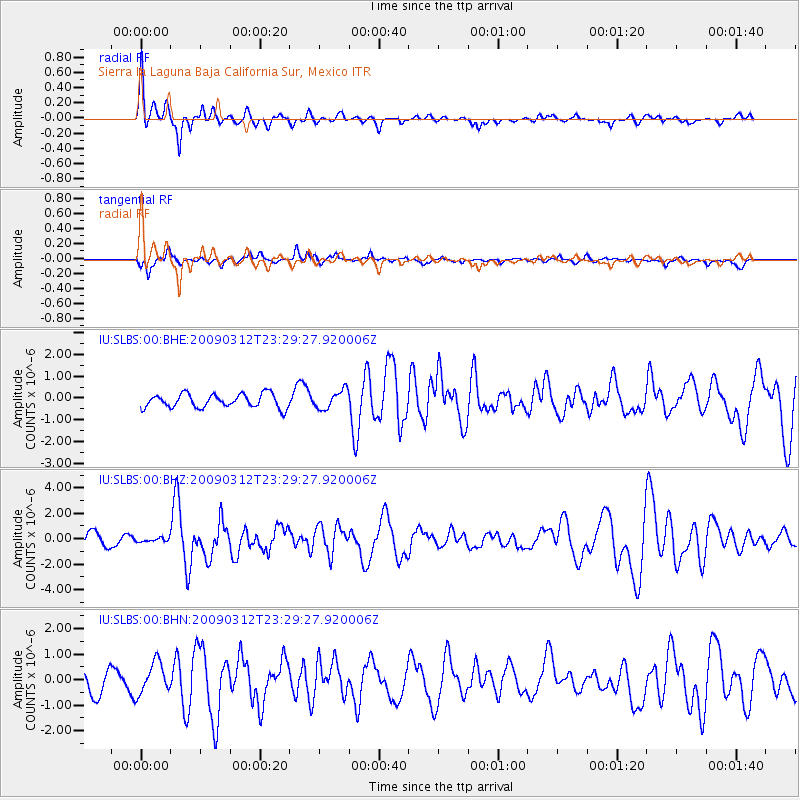
SLBS Sierra la Laguna Baja California Sur, Mexico - Earthquake Result Viewer
*The percent match for this event was below the threshold and hence no stack was calculated.
| Earthquake location: |
South Of Panama |
| Earthquake latitude/longitude: |
5.7/-82.8 |
| Earthquake time(UTC): |
2009/03/12 (071) 23:23:34 GMT |
| Earthquake Depth: |
9.0 km |
| Earthquake Magnitude: |
6.1 MB, 5.9 MS, 6.3 MW, 6.2 MW |
| Earthquake Catalog/Contributor: |
WHDF/NEIC |
|
| Network: |
IU Global Seismograph Network (GSN - IRIS/USGS) |
| Station: |
SLBS Sierra la Laguna Baja California Sur, Mexico |
| Lat/Lon: |
23.69 N/109.94 W |
| Elevation: |
825 m |
|
| Distance: |
31.7 deg |
| Az: |
307.151 deg |
| Baz: |
120.093 deg |
| Ray Param: |
$rayparam |
*The percent match for this event was below the threshold and hence was not used in the summary stack. |
|
| Radial Match: |
76.80276 % |
| Radial Bump: |
400 |
| Transverse Match: |
67.130035 % |
| Transverse Bump: |
325 |
| SOD ConfigId: |
2658 |
| Insert Time: |
2010-03-02 01:21:47.082 +0000 |
| GWidth: |
2.5 |
| Max Bumps: |
400 |
| Tol: |
0.001 |
|
Signal To Noise
| Channel | StoN | STA | LTA |
| IU:SLBS:00:BHZ:20090312T23:29:27.920006Z | 0.24414517 | 1.3992052E-7 | 5.7310376E-7 |
| IU:SLBS:00:BHN:20090312T23:29:27.920006Z | 1.5172254 | 6.070056E-7 | 4.000761E-7 |
| IU:SLBS:00:BHE:20090312T23:29:27.920006Z | 1.3625455 | 4.3022368E-7 | 3.1575E-7 |
| Arrivals |
| Ps | |
| PpPs | |
| PsPs/PpSs | |


