You are here: Home > Network List > TA - USArray Transportable Network (new EarthScope stations) Stations List
> Station MSTX Muleshoe, TX, USA > Earthquake Result Viewer
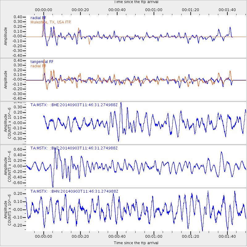
MSTX Muleshoe, TX, USA - Earthquake Result Viewer
*The percent match for this event was below the threshold and hence no stack was calculated.
| Earthquake location: |
Samoa Islands |
| Earthquake latitude/longitude: |
-14.9/-172.9 |
| Earthquake time(UTC): |
2014/09/03 (246) 11:34:40 GMT |
| Earthquake Depth: |
10 km |
| Earthquake Magnitude: |
5.7 MWW, 5.7 MWC, 5.7 MWB |
| Earthquake Catalog/Contributor: |
NEIC PDE/NEIC COMCAT |
|
| Network: |
TA USArray Transportable Network (new EarthScope stations) |
| Station: |
MSTX Muleshoe, TX, USA |
| Lat/Lon: |
33.97 N/102.77 W |
| Elevation: |
1167 m |
|
| Distance: |
82.5 deg |
| Az: |
52.033 deg |
| Baz: |
246.497 deg |
| Ray Param: |
$rayparam |
*The percent match for this event was below the threshold and hence was not used in the summary stack. |
|
| Radial Match: |
67.7868 % |
| Radial Bump: |
309 |
| Transverse Match: |
43.016567 % |
| Transverse Bump: |
324 |
| SOD ConfigId: |
769524 |
| Insert Time: |
2014-09-17 12:08:01.846 +0000 |
| GWidth: |
2.5 |
| Max Bumps: |
400 |
| Tol: |
0.001 |
|
Signal To Noise
| Channel | StoN | STA | LTA |
| TA:MSTX: :BHZ:20140903T11:46:31.274988Z | 3.3479285 | 1.7562161E-7 | 5.2456798E-8 |
| TA:MSTX: :BHN:20140903T11:46:31.274988Z | 1.2664735 | 1.02552654E-7 | 8.097497E-8 |
| TA:MSTX: :BHE:20140903T11:46:31.274988Z | 0.5598403 | 4.0556827E-8 | 7.244356E-8 |
| Arrivals |
| Ps | |
| PpPs | |
| PsPs/PpSs | |


