You are here: Home > Network List > US - United States National Seismic Network Stations List
> Station WMOK Wichita Mountains, Oklahoma, USA > Earthquake Result Viewer
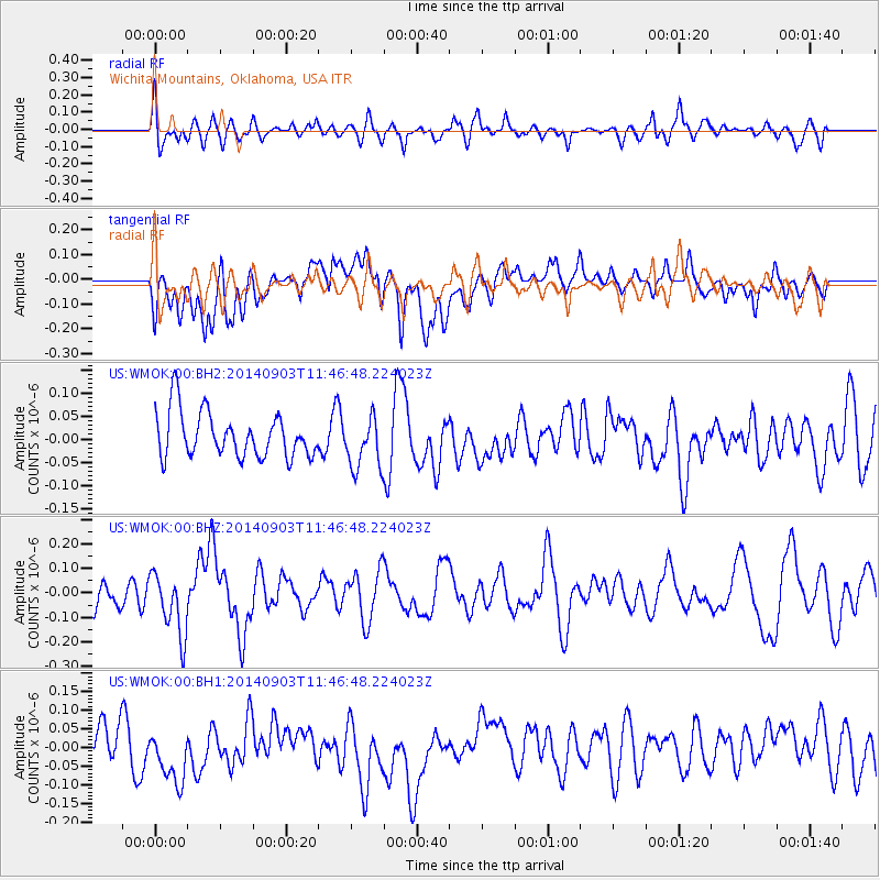
WMOK Wichita Mountains, Oklahoma, USA - Earthquake Result Viewer
*The percent match for this event was below the threshold and hence no stack was calculated.
| Earthquake location: |
Samoa Islands |
| Earthquake latitude/longitude: |
-14.9/-172.9 |
| Earthquake time(UTC): |
2014/09/03 (246) 11:34:40 GMT |
| Earthquake Depth: |
10 km |
| Earthquake Magnitude: |
5.7 MWW, 5.7 MWC, 5.7 MWB |
| Earthquake Catalog/Contributor: |
NEIC PDE/NEIC COMCAT |
|
| Network: |
US United States National Seismic Network |
| Station: |
WMOK Wichita Mountains, Oklahoma, USA |
| Lat/Lon: |
34.74 N/98.78 W |
| Elevation: |
486 m |
|
| Distance: |
85.8 deg |
| Az: |
52.583 deg |
| Baz: |
248.796 deg |
| Ray Param: |
$rayparam |
*The percent match for this event was below the threshold and hence was not used in the summary stack. |
|
| Radial Match: |
52.42112 % |
| Radial Bump: |
400 |
| Transverse Match: |
49.00586 % |
| Transverse Bump: |
400 |
| SOD ConfigId: |
769524 |
| Insert Time: |
2014-09-17 12:12:06.788 +0000 |
| GWidth: |
2.5 |
| Max Bumps: |
400 |
| Tol: |
0.001 |
|
Signal To Noise
| Channel | StoN | STA | LTA |
| US:WMOK:00:BHZ:20140903T11:46:48.224023Z | 2.9040728 | 1.2708146E-7 | 4.375974E-8 |
| US:WMOK:00:BH1:20140903T11:46:48.224023Z | 1.476712 | 8.3618396E-8 | 5.6624717E-8 |
| US:WMOK:00:BH2:20140903T11:46:48.224023Z | 1.1583757 | 5.6730702E-8 | 4.8974353E-8 |
| Arrivals |
| Ps | |
| PpPs | |
| PsPs/PpSs | |


