You are here: Home > Network List > IU - Global Seismograph Network (GSN - IRIS/USGS) Stations List
> Station SLBS Sierra la Laguna Baja California Sur, Mexico > Earthquake Result Viewer
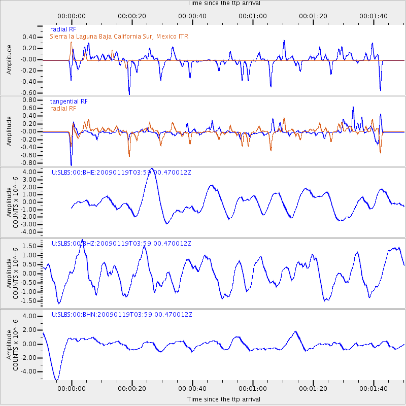
SLBS Sierra la Laguna Baja California Sur, Mexico - Earthquake Result Viewer
*The percent match for this event was below the threshold and hence no stack was calculated.
| Earthquake location: |
Southeast Of Loyalty Islands |
| Earthquake latitude/longitude: |
-22.5/170.8 |
| Earthquake time(UTC): |
2009/01/19 (019) 03:46:37 GMT |
| Earthquake Depth: |
35 km |
| Earthquake Magnitude: |
6.0 MW, 5.3 MB |
| Earthquake Catalog/Contributor: |
WHDF/NEIC |
|
| Network: |
IU Global Seismograph Network (GSN - IRIS/USGS) |
| Station: |
SLBS Sierra la Laguna Baja California Sur, Mexico |
| Lat/Lon: |
23.69 N/109.94 W |
| Elevation: |
825 m |
|
| Distance: |
89.6 deg |
| Az: |
64.247 deg |
| Baz: |
245.329 deg |
| Ray Param: |
$rayparam |
*The percent match for this event was below the threshold and hence was not used in the summary stack. |
|
| Radial Match: |
62.77704 % |
| Radial Bump: |
338 |
| Transverse Match: |
48.568417 % |
| Transverse Bump: |
315 |
| SOD ConfigId: |
2658 |
| Insert Time: |
2010-03-02 01:22:08.898 +0000 |
| GWidth: |
2.5 |
| Max Bumps: |
400 |
| Tol: |
0.001 |
|
Signal To Noise
| Channel | StoN | STA | LTA |
| IU:SLBS:00:BHZ:20090119T03:59:00.470012Z | 2.174104 | 1.0348072E-6 | 4.7596947E-7 |
| IU:SLBS:00:BHN:20090119T03:59:00.470012Z | 0.609123 | 8.000499E-7 | 1.3134456E-6 |
| IU:SLBS:00:BHE:20090119T03:59:00.470012Z | 2.3078406 | 1.7626826E-6 | 7.6378006E-7 |
| Arrivals |
| Ps | |
| PpPs | |
| PsPs/PpSs | |


