You are here: Home > Network List > TA - USArray Transportable Network (new EarthScope stations) Stations List
> Station G59A Clarenceville, QC, USA > Earthquake Result Viewer
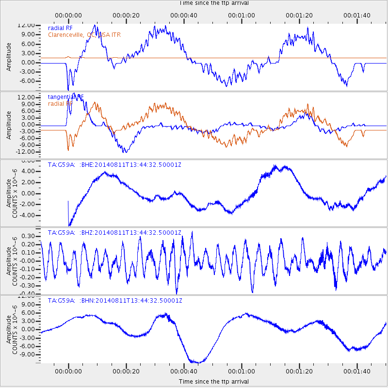
G59A Clarenceville, QC, USA - Earthquake Result Viewer
*The percent match for this event was below the threshold and hence no stack was calculated.
| Earthquake location: |
West Chile Rise |
| Earthquake latitude/longitude: |
-41.3/-85.0 |
| Earthquake time(UTC): |
2014/08/11 (223) 13:32:20 GMT |
| Earthquake Depth: |
10 km |
| Earthquake Magnitude: |
5.5 MWW, 5.6 MWB, 5.6 MWC |
| Earthquake Catalog/Contributor: |
NEIC PDE/NEIC COMCAT |
|
| Network: |
TA USArray Transportable Network (new EarthScope stations) |
| Station: |
G59A Clarenceville, QC, USA |
| Lat/Lon: |
45.08 N/73.18 W |
| Elevation: |
36 m |
|
| Distance: |
86.7 deg |
| Az: |
8.327 deg |
| Baz: |
188.856 deg |
| Ray Param: |
$rayparam |
*The percent match for this event was below the threshold and hence was not used in the summary stack. |
|
| Radial Match: |
36.797234 % |
| Radial Bump: |
400 |
| Transverse Match: |
62.72033 % |
| Transverse Bump: |
400 |
| SOD ConfigId: |
769524 |
| Insert Time: |
2014-09-17 16:16:19.461 +0000 |
| GWidth: |
2.5 |
| Max Bumps: |
400 |
| Tol: |
0.001 |
|
Signal To Noise
| Channel | StoN | STA | LTA |
| TA:G59A: :BHZ:20140811T13:44:32.50001Z | 1.1541775 | 1.4092801E-7 | 1.2210255E-7 |
| TA:G59A: :BHN:20140811T13:44:32.50001Z | 2.015259 | 9.591987E-6 | 4.7596795E-6 |
| TA:G59A: :BHE:20140811T13:44:32.50001Z | 0.6452816 | 1.6557044E-6 | 2.5658633E-6 |
| Arrivals |
| Ps | |
| PpPs | |
| PsPs/PpSs | |


