You are here: Home > Network List > AG - Arkansas Seismic Network Stations List
> Station LCAR Lake Charles,AR > Earthquake Result Viewer
LCAR Lake Charles,AR - Earthquake Result Viewer
| Earthquake location: |
Easter Island Region |
| Earthquake latitude/longitude: |
-26.5/-114.6 |
| Earthquake time(UTC): |
2014/09/03 (246) 20:34:00 GMT |
| Earthquake Depth: |
10 km |
| Earthquake Magnitude: |
5.9 MWB |
| Earthquake Catalog/Contributor: |
NEIC PDE/NEIC COMCAT |
|
| Network: |
AG Arkansas Seismic Network |
| Station: |
LCAR Lake Charles,AR |
| Lat/Lon: |
36.07 N/91.15 W |
| Elevation: |
103 m |
|
| Distance: |
66.1 deg |
| Az: |
20.67 deg |
| Baz: |
202.971 deg |
| Ray Param: |
0.057834305 |
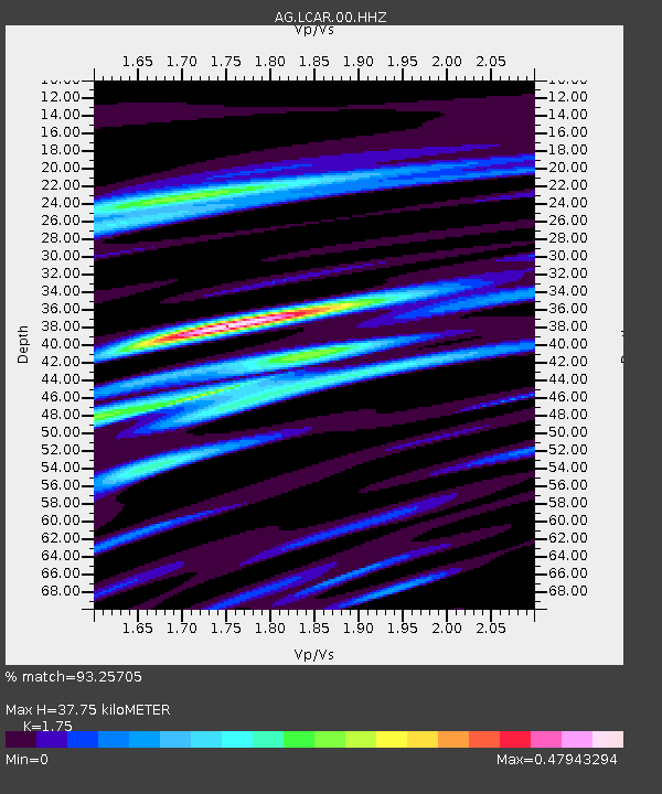
| Estimated Moho Depth: |
37.75 km |
| Estimated Crust Vp/Vs: |
1.75 |
| Assumed Crust Vp: |
6.53 km/s |
| Estimated Crust Vs: |
3.732 km/s |
| Estimated Crust Poisson's Ratio: |
0.26 |
|
| Radial Match: |
93.25705 % |
| Radial Bump: |
303 |
| Transverse Match: |
64.73105 % |
| Transverse Bump: |
400 |
| SOD ConfigId: |
769524 |
| Insert Time: |
2014-09-17 20:37:59.831 +0000 |
| GWidth: |
2.5 |
| Max Bumps: |
400 |
| Tol: |
0.001 |
|
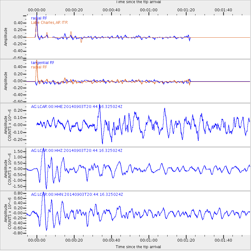
Signal To Noise
| Channel | StoN | STA | LTA |
| AG:LCAR:00:HHZ:20140903T20:44:16.325024Z | 15.079947 | 9.052567E-7 | 6.003049E-8 |
| AG:LCAR:00:HHN:20140903T20:44:16.325024Z | 17.1359 | 4.2308923E-7 | 2.4690227E-8 |
| AG:LCAR:00:HHE:20140903T20:44:16.325024Z | 2.570976 | 1.0247728E-7 | 3.985929E-8 |
| Arrivals |
| Ps | 4.5 SECOND |
| PpPs | 15 SECOND |
| PsPs/PpSs | 20 SECOND |


