You are here: Home > Network List > AZ - ANZA Regional Network Stations List
> Station MONP2 Monument Peak TA Vault, Mt. Laguna, CA, USA > Earthquake Result Viewer
MONP2 Monument Peak TA Vault, Mt. Laguna, CA, USA - Earthquake Result Viewer

| Earthquake location: |
Easter Island Region |
| Earthquake latitude/longitude: |
-26.5/-114.6 |
| Earthquake time(UTC): |
2014/09/03 (246) 20:34:00 GMT |
| Earthquake Depth: |
10 km |
| Earthquake Magnitude: |
5.9 MWB |
| Earthquake Catalog/Contributor: |
NEIC PDE/NEIC COMCAT |
|
| Network: |
AZ ANZA Regional Network |
| Station: |
MONP2 Monument Peak TA Vault, Mt. Laguna, CA, USA |
| Lat/Lon: |
32.89 N/116.42 W |
| Elevation: |
1000 m |
|
| Distance: |
59.1 deg |
| Az: |
358.242 deg |
| Baz: |
178.128 deg |
| Ray Param: |
0.062388245 |
| Estimated Moho Depth: |
31.25 km |
| Estimated Crust Vp/Vs: |
1.74 |
| Assumed Crust Vp: |
6.264 km/s |
| Estimated Crust Vs: |
3.61 km/s |
| Estimated Crust Poisson's Ratio: |
0.25 |
|
| Radial Match: |
84.862404 % |
| Radial Bump: |
340 |
| Transverse Match: |
62.004913 % |
| Transverse Bump: |
337 |
| SOD ConfigId: |
769524 |
| Insert Time: |
2014-09-17 20:43:42.358 +0000 |
| GWidth: |
2.5 |
| Max Bumps: |
400 |
| Tol: |
0.001 |
|
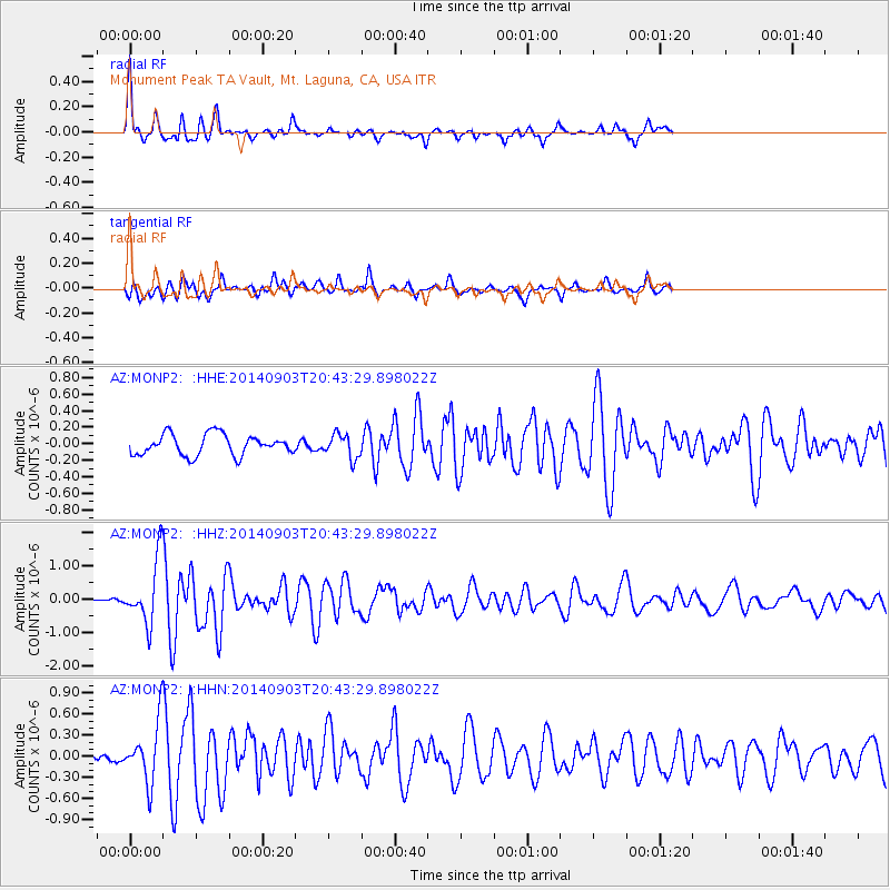
Signal To Noise
| Channel | StoN | STA | LTA |
| AZ:MONP2: :HHZ:20140903T20:43:29.898022Z | 9.587824 | 9.505713E-7 | 9.91436E-8 |
| AZ:MONP2: :HHN:20140903T20:43:29.898022Z | 4.1296897 | 4.0830938E-7 | 9.887168E-8 |
| AZ:MONP2: :HHE:20140903T20:43:29.898022Z | 1.1571779 | 1.4449384E-7 | 1.2486744E-7 |
| Arrivals |
| Ps | 3.8 SECOND |
| PpPs | 13 SECOND |
| PsPs/PpSs | 17 SECOND |


