You are here: Home > Network List > ET - CERI Southern Appalachian seismic Network Stations List
> Station CPCT Cooper Cave,TN > Earthquake Result Viewer
CPCT Cooper Cave,TN - Earthquake Result Viewer
| Earthquake location: |
Easter Island Region |
| Earthquake latitude/longitude: |
-26.5/-114.6 |
| Earthquake time(UTC): |
2014/09/03 (246) 20:34:00 GMT |
| Earthquake Depth: |
10 km |
| Earthquake Magnitude: |
5.9 MWB |
| Earthquake Catalog/Contributor: |
NEIC PDE/NEIC COMCAT |
|
| Network: |
ET CERI Southern Appalachian seismic Network |
| Station: |
CPCT Cooper Cave,TN |
| Lat/Lon: |
35.45 N/84.52 W |
| Elevation: |
275 m |
|
| Distance: |
67.9 deg |
| Az: |
26.23 deg |
| Baz: |
209.006 deg |
| Ray Param: |
0.05664604 |
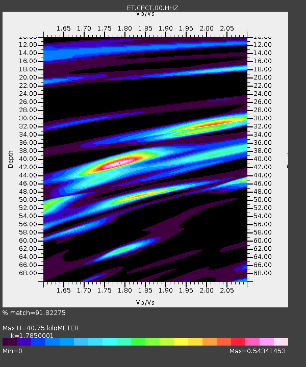
| Estimated Moho Depth: |
40.75 km |
| Estimated Crust Vp/Vs: |
1.79 |
| Assumed Crust Vp: |
6.35 km/s |
| Estimated Crust Vs: |
3.557 km/s |
| Estimated Crust Poisson's Ratio: |
0.27 |
|
| Radial Match: |
91.82275 % |
| Radial Bump: |
313 |
| Transverse Match: |
67.792915 % |
| Transverse Bump: |
400 |
| SOD ConfigId: |
790520 |
| Insert Time: |
2014-09-17 20:57:16.087 +0000 |
| GWidth: |
2.5 |
| Max Bumps: |
400 |
| Tol: |
0.001 |
|

Signal To Noise
| Channel | StoN | STA | LTA |
| ET:CPCT:00:HHZ:20140903T20:44:27.794995Z | 13.86052 | 9.081909E-7 | 6.552358E-8 |
| ET:CPCT:00:HHN:20140903T20:44:27.794995Z | 5.561923 | 3.49127E-7 | 6.2770916E-8 |
| ET:CPCT:00:HHE:20140903T20:44:27.794995Z | 4.1312127 | 1.8936464E-7 | 4.583754E-8 |
| Arrivals |
| Ps | 5.2 SECOND |
| PpPs | 17 SECOND |
| PsPs/PpSs | 22 SECOND |


