You are here: Home > Network List > G - GEOSCOPE Stations List
> Station MPG Montagne des Peres, French Guyana > Earthquake Result Viewer
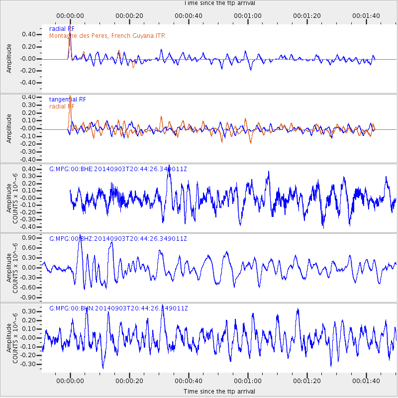
MPG Montagne des Peres, French Guyana - Earthquake Result Viewer
*The percent match for this event was below the threshold and hence no stack was calculated.
| Earthquake location: |
Easter Island Region |
| Earthquake latitude/longitude: |
-26.5/-114.6 |
| Earthquake time(UTC): |
2014/09/03 (246) 20:34:00 GMT |
| Earthquake Depth: |
10 km |
| Earthquake Magnitude: |
5.9 MWB |
| Earthquake Catalog/Contributor: |
NEIC PDE/NEIC COMCAT |
|
| Network: |
G GEOSCOPE |
| Station: |
MPG Montagne des Peres, French Guyana |
| Lat/Lon: |
5.11 N/52.64 W |
| Elevation: |
147 m |
|
| Distance: |
67.7 deg |
| Az: |
71.91 deg |
| Baz: |
238.741 deg |
| Ray Param: |
$rayparam |
*The percent match for this event was below the threshold and hence was not used in the summary stack. |
|
| Radial Match: |
75.653015 % |
| Radial Bump: |
400 |
| Transverse Match: |
61.634937 % |
| Transverse Bump: |
400 |
| SOD ConfigId: |
790520 |
| Insert Time: |
2014-09-17 20:57:30.576 +0000 |
| GWidth: |
2.5 |
| Max Bumps: |
400 |
| Tol: |
0.001 |
|
Signal To Noise
| Channel | StoN | STA | LTA |
| G:MPG:00:BHZ:20140903T20:44:26.349011Z | 3.3228776 | 4.5653286E-7 | 1.3739081E-7 |
| G:MPG:00:BHN:20140903T20:44:26.349011Z | 1.2945142 | 9.186451E-8 | 7.096447E-8 |
| G:MPG:00:BHE:20140903T20:44:26.349011Z | 2.5718594 | 2.0931192E-7 | 8.138545E-8 |
| Arrivals |
| Ps | |
| PpPs | |
| PsPs/PpSs | |


