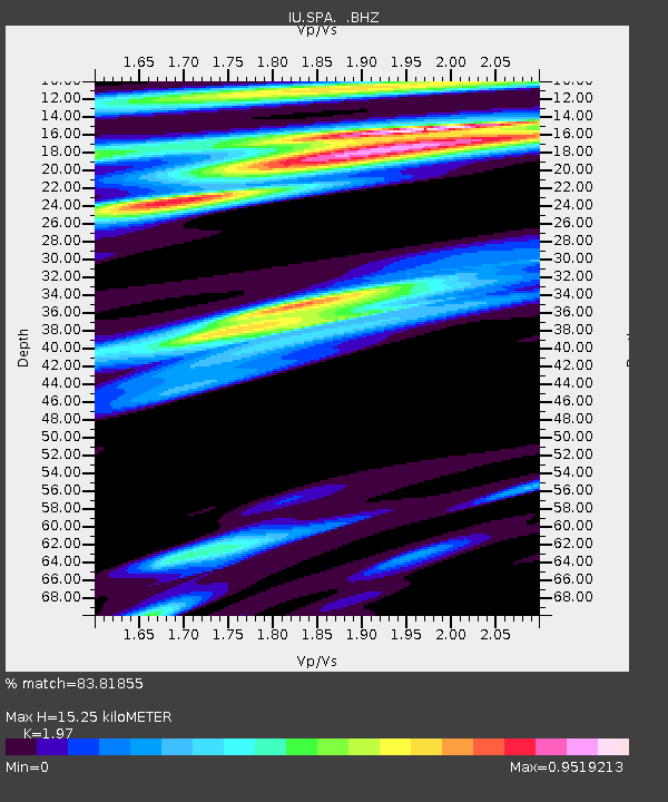
SPA South Pole, Antarctica - Earthquake Result Viewer
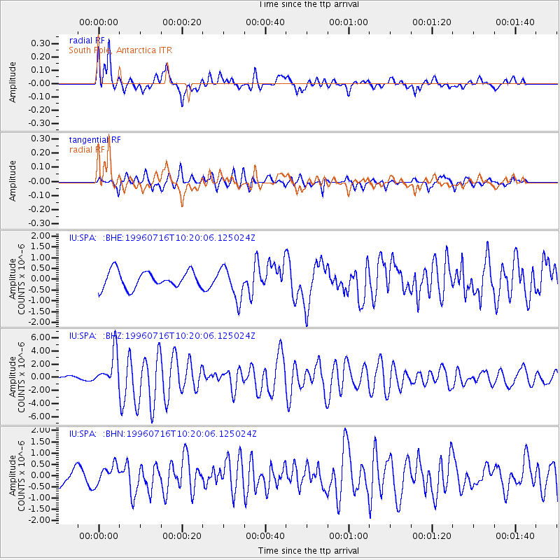
Earthquake location: Minahassa Peninsula, Sulawesi
Earthquake latitude/longitude: 1.0/120.3
Earthquake time(UTC): 1996/07/16 (198) 10:07:36 GMT
Earthquake Depth: 33 km
Earthquake Magnitude: 6.0 MB, 6.4 MS, 6.6 UNKNOWN, 6.6 MW
Earthquake Catalog/Contributor: WHDF/NEIC
Network: IU Global Seismograph Network (GSN - IRIS/USGS)
Station: SPA South Pole, Antarctica
Lat/Lon: 90.00 S/115.00 E
Elevation: 2927 m
Distance: 91.0 deg
Az: 180.0 deg
Baz: 5.254 deg
Ray Param: 0.041628994
Estimated Moho Depth: 15.25 km
Estimated Crust Vp/Vs: 1.97
Assumed Crust Vp: 6.261 km/s
Estimated Crust Vs: 3.178 km/s
Estimated Crust Poisson's Ratio: 0.33
Radial Match: 83.81855 %
Radial Bump: 400
Transverse Match: 80.240524 %
Transverse Bump: 400
SOD ConfigId: 4480
Insert Time: 2010-03-02 01:22:52.801 +0000
GWidth: 2.5
Max Bumps: 400
Tol: 0.001

Signal To Noise

ChannelStoNSTALTA
IU:SPA: :BHZ:19960716T10:20:06.125024Z7.2016982.711197E-63.764664E-7
IU:SPA: :BHN:19960716T10:20:06.125024Z1.39515824.0865882E-72.9291218E-7
IU:SPA: :BHE:19960716T10:20:06.125024Z1.97417717.703195E-73.9019778E-7
Arrivals
Ps2.4 SECOND
PpPs7.1 SECOND
PsPs/PpSs9.5 SECOND