You are here: Home > Network List > LD - Lamont-Doherty Cooperative Seismographic Network Stations List
> Station MMNY Mount Morris Dam, NY > Earthquake Result Viewer
MMNY Mount Morris Dam, NY - Earthquake Result Viewer
| Earthquake location: |
Easter Island Region |
| Earthquake latitude/longitude: |
-26.5/-114.6 |
| Earthquake time(UTC): |
2014/09/03 (246) 20:34:00 GMT |
| Earthquake Depth: |
10 km |
| Earthquake Magnitude: |
5.9 MWB |
| Earthquake Catalog/Contributor: |
NEIC PDE/NEIC COMCAT |
|
| Network: |
LD Lamont-Doherty Cooperative Seismographic Network |
| Station: |
MMNY Mount Morris Dam, NY |
| Lat/Lon: |
42.73 N/77.91 W |
| Elevation: |
241 m |
|
| Distance: |
76.8 deg |
| Az: |
26.906 deg |
| Baz: |
213.377 deg |
| Ray Param: |
0.050755132 |
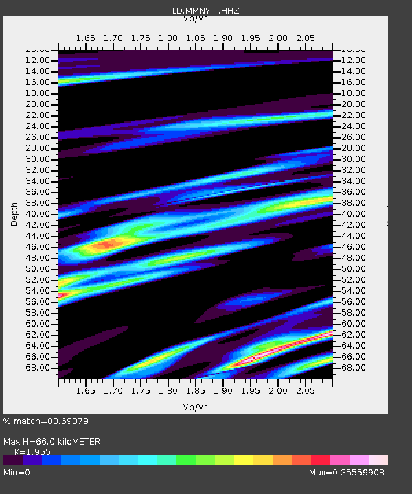
| Estimated Moho Depth: |
66.0 km |
| Estimated Crust Vp/Vs: |
1.96 |
| Assumed Crust Vp: |
6.476 km/s |
| Estimated Crust Vs: |
3.312 km/s |
| Estimated Crust Poisson's Ratio: |
0.32 |
|
| Radial Match: |
83.69379 % |
| Radial Bump: |
294 |
| Transverse Match: |
67.47473 % |
| Transverse Bump: |
400 |
| SOD ConfigId: |
790520 |
| Insert Time: |
2014-09-17 21:02:05.190 +0000 |
| GWidth: |
2.5 |
| Max Bumps: |
400 |
| Tol: |
0.001 |
|

Signal To Noise
| Channel | StoN | STA | LTA |
| LD:MMNY: :HHZ:20140903T20:45:20.65498Z | 5.443697 | 7.9341294E-7 | 1.4574891E-7 |
| LD:MMNY: :HHN:20140903T20:45:20.65498Z | 2.3681843 | 1.9814638E-7 | 8.3670166E-8 |
| LD:MMNY: :HHE:20140903T20:45:20.65498Z | 1.5122362 | 2.2363393E-7 | 1.4788293E-7 |
| Arrivals |
| Ps | 10 SECOND |
| PpPs | 29 SECOND |
| PsPs/PpSs | 39 SECOND |


