You are here: Home > Network List > N4 - Central and EAstern US Network Stations List
> Station 154A Montrose, GA, USA > Earthquake Result Viewer
154A Montrose, GA, USA - Earthquake Result Viewer
| Earthquake location: |
Easter Island Region |
| Earthquake latitude/longitude: |
-26.5/-114.6 |
| Earthquake time(UTC): |
2014/09/03 (246) 20:34:00 GMT |
| Earthquake Depth: |
10 km |
| Earthquake Magnitude: |
5.9 MWB |
| Earthquake Catalog/Contributor: |
NEIC PDE/NEIC COMCAT |
|
| Network: |
N4 Central and EAstern US Network |
| Station: |
154A Montrose, GA, USA |
| Lat/Lon: |
32.61 N/83.11 W |
| Elevation: |
111 m |
|
| Distance: |
66.0 deg |
| Az: |
28.87 deg |
| Baz: |
210.827 deg |
| Ray Param: |
0.0578718 |
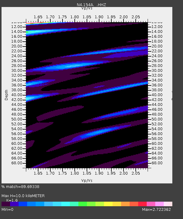
| Estimated Moho Depth: |
10.0 km |
| Estimated Crust Vp/Vs: |
1.60 |
| Assumed Crust Vp: |
6.565 km/s |
| Estimated Crust Vs: |
4.103 km/s |
| Estimated Crust Poisson's Ratio: |
0.18 |
|
| Radial Match: |
89.69338 % |
| Radial Bump: |
400 |
| Transverse Match: |
71.286674 % |
| Transverse Bump: |
400 |
| SOD ConfigId: |
790520 |
| Insert Time: |
2014-09-17 21:04:19.873 +0000 |
| GWidth: |
2.5 |
| Max Bumps: |
400 |
| Tol: |
0.001 |
|

Signal To Noise
| Channel | StoN | STA | LTA |
| N4:154A: :HHZ:20140903T20:44:15.950024Z | 7.5841007 | 1.016722E-6 | 1.3405965E-7 |
| N4:154A: :HHN:20140903T20:44:15.950024Z | 2.7360435 | 6.357672E-7 | 2.3236737E-7 |
| N4:154A: :HHE:20140903T20:44:15.950024Z | 1.4171996 | 3.3959768E-7 | 2.3962588E-7 |
| Arrivals |
| Ps | 1.0 SECOND |
| PpPs | 3.8 SECOND |
| PsPs/PpSs | 4.7 SECOND |


