You are here: Home > Network List > N4 - Central and EAstern US Network Stations List
> Station 352A Blakely, GA, USA > Earthquake Result Viewer
352A Blakely, GA, USA - Earthquake Result Viewer
| Earthquake location: |
Easter Island Region |
| Earthquake latitude/longitude: |
-26.5/-114.6 |
| Earthquake time(UTC): |
2014/09/03 (246) 20:34:00 GMT |
| Earthquake Depth: |
10 km |
| Earthquake Magnitude: |
5.9 MWB |
| Earthquake Catalog/Contributor: |
NEIC PDE/NEIC COMCAT |
|
| Network: |
N4 Central and EAstern US Network |
| Station: |
352A Blakely, GA, USA |
| Lat/Lon: |
31.48 N/84.93 W |
| Elevation: |
101 m |
|
| Distance: |
64.3 deg |
| Az: |
28.023 deg |
| Baz: |
209.51 deg |
| Ray Param: |
0.059014585 |
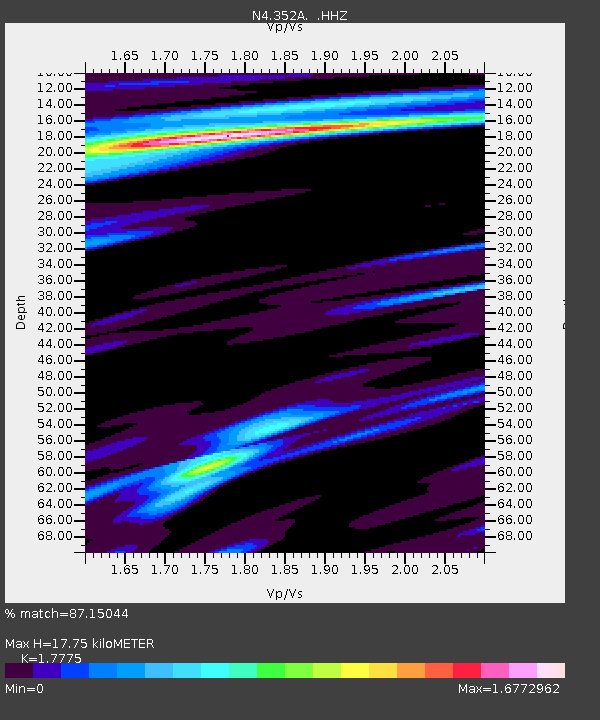
| Estimated Moho Depth: |
17.75 km |
| Estimated Crust Vp/Vs: |
1.78 |
| Assumed Crust Vp: |
6.347 km/s |
| Estimated Crust Vs: |
3.571 km/s |
| Estimated Crust Poisson's Ratio: |
0.27 |
|
| Radial Match: |
87.15044 % |
| Radial Bump: |
271 |
| Transverse Match: |
70.74904 % |
| Transverse Bump: |
278 |
| SOD ConfigId: |
790520 |
| Insert Time: |
2014-09-17 21:04:40.613 +0000 |
| GWidth: |
2.5 |
| Max Bumps: |
400 |
| Tol: |
0.001 |
|

Signal To Noise
| Channel | StoN | STA | LTA |
| N4:352A: :HHZ:20140903T20:44:04.589978Z | 10.773326 | 1.2467094E-6 | 1.15721875E-7 |
| N4:352A: :HHN:20140903T20:44:04.589978Z | 1.6280471 | 2.6696392E-7 | 1.63978E-7 |
| N4:352A: :HHE:20140903T20:44:04.589978Z | 1.3981746 | 2.1034457E-7 | 1.5044228E-7 |
| Arrivals |
| Ps | 2.3 SECOND |
| PpPs | 7.5 SECOND |
| PsPs/PpSs | 9.7 SECOND |


