You are here: Home > Network List > N4 - Central and EAstern US Network Stations List
> Station 451A Vernon, FL, USA > Earthquake Result Viewer
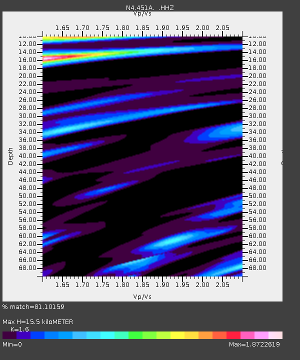
451A Vernon, FL, USA - Earthquake Result Viewer
| Earthquake location: |
Easter Island Region |
| Earthquake latitude/longitude: |
-26.5/-114.6 |
| Earthquake time(UTC): |
2014/09/03 (246) 20:34:00 GMT |
| Earthquake Depth: |
10 km |
| Earthquake Magnitude: |
5.9 MWB |
| Earthquake Catalog/Contributor: |
NEIC PDE/NEIC COMCAT |
|
| Network: |
N4 Central and EAstern US Network |
| Station: |
451A Vernon, FL, USA |
| Lat/Lon: |
30.62 N/85.75 W |
| Elevation: |
20 m |
|
| Distance: |
63.2 deg |
| Az: |
27.808 deg |
| Baz: |
208.994 deg |
| Ray Param: |
0.059731893 |
| Estimated Moho Depth: |
15.5 km |
| Estimated Crust Vp/Vs: |
1.60 |
| Assumed Crust Vp: |
6.347 km/s |
| Estimated Crust Vs: |
3.967 km/s |
| Estimated Crust Poisson's Ratio: |
0.18 |
|
| Radial Match: |
81.10159 % |
| Radial Bump: |
400 |
| Transverse Match: |
60.21873 % |
| Transverse Bump: |
400 |
| SOD ConfigId: |
790520 |
| Insert Time: |
2014-09-17 21:04:45.733 +0000 |
| GWidth: |
2.5 |
| Max Bumps: |
400 |
| Tol: |
0.001 |
|

Signal To Noise
| Channel | StoN | STA | LTA |
| N4:451A: :HHZ:20140903T20:43:57.380017Z | 6.009429 | 1.2387638E-6 | 2.0613669E-7 |
| N4:451A: :HHN:20140903T20:43:57.380017Z | 1.5355535 | 4.003352E-7 | 2.607107E-7 |
| N4:451A: :HHE:20140903T20:43:57.380017Z | 1.1976004 | 2.5268648E-7 | 2.1099397E-7 |
| Arrivals |
| Ps | 1.5 SECOND |
| PpPs | 6.1 SECOND |
| PsPs/PpSs | 7.6 SECOND |


