You are here: Home > Network List > TA - USArray Transportable Network (new EarthScope stations) Stations List
> Station 435B Jarrell, TX, USA > Earthquake Result Viewer
435B Jarrell, TX, USA - Earthquake Result Viewer
| Earthquake location: |
Easter Island Region |
| Earthquake latitude/longitude: |
-26.5/-114.6 |
| Earthquake time(UTC): |
2014/09/03 (246) 20:34:00 GMT |
| Earthquake Depth: |
10 km |
| Earthquake Magnitude: |
5.9 MWB |
| Earthquake Catalog/Contributor: |
NEIC PDE/NEIC COMCAT |
|
| Network: |
TA USArray Transportable Network (new EarthScope stations) |
| Station: |
435B Jarrell, TX, USA |
| Lat/Lon: |
30.78 N/97.58 W |
| Elevation: |
248 m |
|
| Distance: |
59.3 deg |
| Az: |
17.061 deg |
| Baz: |
197.78 deg |
| Ray Param: |
0.062284928 |
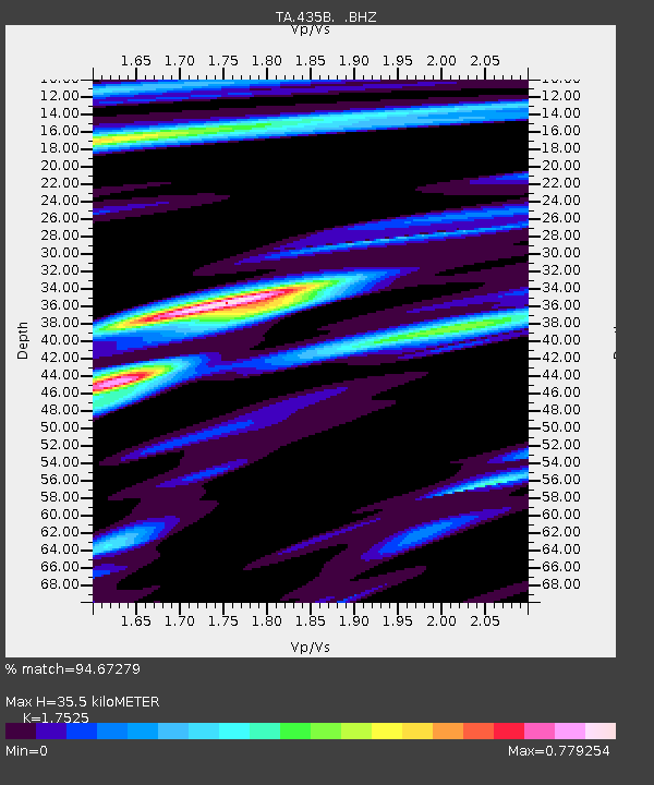
| Estimated Moho Depth: |
35.5 km |
| Estimated Crust Vp/Vs: |
1.75 |
| Assumed Crust Vp: |
6.347 km/s |
| Estimated Crust Vs: |
3.622 km/s |
| Estimated Crust Poisson's Ratio: |
0.26 |
|
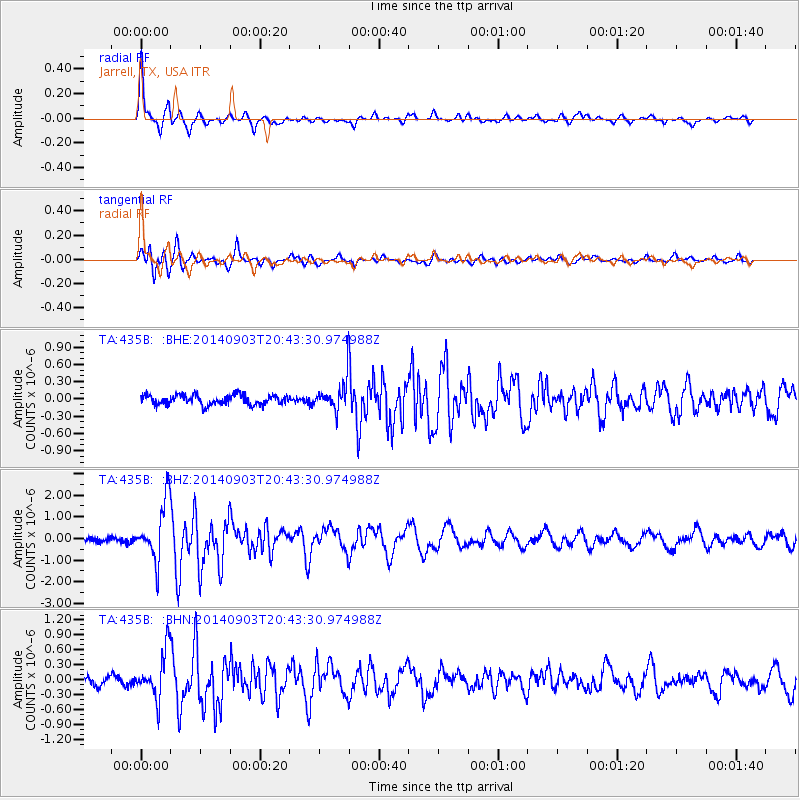
| Radial Match: |
94.67279 % |
| Radial Bump: |
317 |
| Transverse Match: |
89.003975 % |
| Transverse Bump: |
400 |
| SOD ConfigId: |
790520 |
| Insert Time: |
2014-09-17 21:17:00.621 +0000 |
| GWidth: |
2.5 |
| Max Bumps: |
400 |
| Tol: |
0.001 |
|
Signal To Noise
| Channel | StoN | STA | LTA |
| TA:435B: :BHZ:20140903T20:43:30.974988Z | 10.396509 | 1.3561728E-6 | 1.3044502E-7 |
| TA:435B: :BHN:20140903T20:43:30.974988Z | 5.513679 | 4.732574E-7 | 8.583333E-8 |
| TA:435B: :BHE:20140903T20:43:30.974988Z | 2.9825168 | 2.5200876E-7 | 8.449533E-8 |
| Arrivals |
| Ps | 4.4 SECOND |
| PpPs | 15 SECOND |
| PsPs/PpSs | 19 SECOND |


