You are here: Home > Network List > TA - USArray Transportable Network (new EarthScope stations) Stations List
> Station E62A Clayton Lake, ME, USA > Earthquake Result Viewer
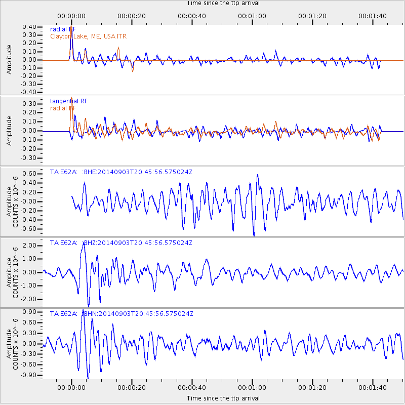
E62A Clayton Lake, ME, USA - Earthquake Result Viewer
*The percent match for this event was below the threshold and hence no stack was calculated.
| Earthquake location: |
Easter Island Region |
| Earthquake latitude/longitude: |
-26.5/-114.6 |
| Earthquake time(UTC): |
2014/09/03 (246) 20:34:00 GMT |
| Earthquake Depth: |
10 km |
| Earthquake Magnitude: |
5.9 MWB |
| Earthquake Catalog/Contributor: |
NEIC PDE/NEIC COMCAT |
|
| Network: |
TA USArray Transportable Network (new EarthScope stations) |
| Station: |
E62A Clayton Lake, ME, USA |
| Lat/Lon: |
46.62 N/69.52 W |
| Elevation: |
356 m |
|
| Distance: |
83.5 deg |
| Az: |
29.437 deg |
| Baz: |
219.695 deg |
| Ray Param: |
$rayparam |
*The percent match for this event was below the threshold and hence was not used in the summary stack. |
|
| Radial Match: |
73.80442 % |
| Radial Bump: |
400 |
| Transverse Match: |
67.10917 % |
| Transverse Bump: |
400 |
| SOD ConfigId: |
790520 |
| Insert Time: |
2014-09-17 21:18:24.083 +0000 |
| GWidth: |
2.5 |
| Max Bumps: |
400 |
| Tol: |
0.001 |
|
Signal To Noise
| Channel | StoN | STA | LTA |
| TA:E62A: :BHZ:20140903T20:45:56.575024Z | 6.426022 | 1.1492695E-6 | 1.7884616E-7 |
| TA:E62A: :BHN:20140903T20:45:56.575024Z | 3.3474772 | 4.7318133E-7 | 1.4135462E-7 |
| TA:E62A: :BHE:20140903T20:45:56.575024Z | 1.3731728 | 1.9965618E-7 | 1.4539772E-7 |
| Arrivals |
| Ps | |
| PpPs | |
| PsPs/PpSs | |


