You are here: Home > Network List > TA - USArray Transportable Network (new EarthScope stations) Stations List
> Station G59A Clarenceville, QC, USA > Earthquake Result Viewer
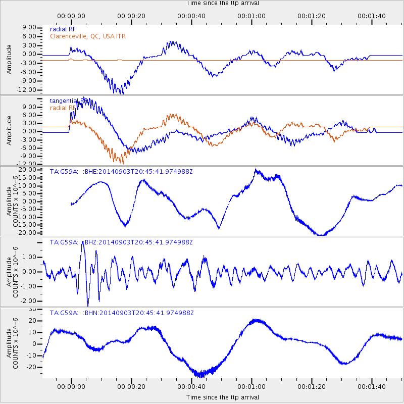
G59A Clarenceville, QC, USA - Earthquake Result Viewer
*The percent match for this event was below the threshold and hence no stack was calculated.
| Earthquake location: |
Easter Island Region |
| Earthquake latitude/longitude: |
-26.5/-114.6 |
| Earthquake time(UTC): |
2014/09/03 (246) 20:34:00 GMT |
| Earthquake Depth: |
10 km |
| Earthquake Magnitude: |
5.9 MWB |
| Earthquake Catalog/Contributor: |
NEIC PDE/NEIC COMCAT |
|
| Network: |
TA USArray Transportable Network (new EarthScope stations) |
| Station: |
G59A Clarenceville, QC, USA |
| Lat/Lon: |
45.08 N/73.18 W |
| Elevation: |
36 m |
|
| Distance: |
80.7 deg |
| Az: |
28.375 deg |
| Baz: |
216.932 deg |
| Ray Param: |
$rayparam |
*The percent match for this event was below the threshold and hence was not used in the summary stack. |
|
| Radial Match: |
46.154305 % |
| Radial Bump: |
400 |
| Transverse Match: |
80.47944 % |
| Transverse Bump: |
400 |
| SOD ConfigId: |
790520 |
| Insert Time: |
2014-09-17 21:19:13.829 +0000 |
| GWidth: |
2.5 |
| Max Bumps: |
400 |
| Tol: |
0.001 |
|
Signal To Noise
| Channel | StoN | STA | LTA |
| TA:G59A: :BHZ:20140903T20:45:41.974988Z | 4.732729 | 9.986713E-7 | 2.1101384E-7 |
| TA:G59A: :BHN:20140903T20:45:41.974988Z | 0.68218166 | 8.501029E-6 | 1.2461533E-5 |
| TA:G59A: :BHE:20140903T20:45:41.974988Z | 0.32508528 | 2.9115151E-6 | 8.956158E-6 |
| Arrivals |
| Ps | |
| PpPs | |
| PsPs/PpSs | |


