You are here: Home > Network List > TA - USArray Transportable Network (new EarthScope stations) Stations List
> Station J59A Piesco, NY, USA > Earthquake Result Viewer
J59A Piesco, NY, USA - Earthquake Result Viewer
| Earthquake location: |
Easter Island Region |
| Earthquake latitude/longitude: |
-26.5/-114.6 |
| Earthquake time(UTC): |
2014/09/03 (246) 20:34:00 GMT |
| Earthquake Depth: |
10 km |
| Earthquake Magnitude: |
5.9 MWB |
| Earthquake Catalog/Contributor: |
NEIC PDE/NEIC COMCAT |
|
| Network: |
TA USArray Transportable Network (new EarthScope stations) |
| Station: |
J59A Piesco, NY, USA |
| Lat/Lon: |
43.46 N/74.50 W |
| Elevation: |
541 m |
|
| Distance: |
78.8 deg |
| Az: |
28.575 deg |
| Baz: |
216.047 deg |
| Ray Param: |
0.04938577 |
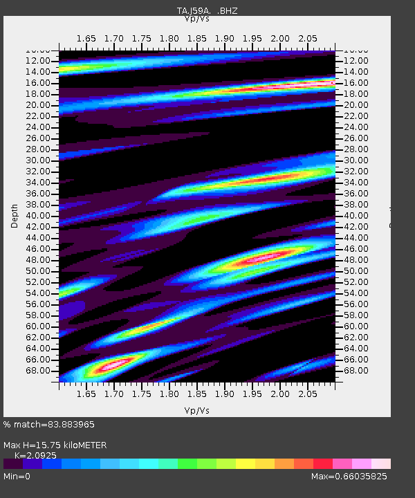
| Estimated Moho Depth: |
15.75 km |
| Estimated Crust Vp/Vs: |
2.09 |
| Assumed Crust Vp: |
6.419 km/s |
| Estimated Crust Vs: |
3.068 km/s |
| Estimated Crust Poisson's Ratio: |
0.35 |
|
| Radial Match: |
83.883965 % |
| Radial Bump: |
400 |
| Transverse Match: |
67.69512 % |
| Transverse Bump: |
400 |
| SOD ConfigId: |
790520 |
| Insert Time: |
2014-09-17 21:20:58.932 +0000 |
| GWidth: |
2.5 |
| Max Bumps: |
400 |
| Tol: |
0.001 |
|

Signal To Noise
| Channel | StoN | STA | LTA |
| TA:J59A: :BHZ:20140903T20:45:31.873975Z | 9.294789 | 8.1431557E-7 | 8.76099E-8 |
| TA:J59A: :BHN:20140903T20:45:31.873975Z | 2.7490919 | 2.1989588E-7 | 7.998855E-8 |
| TA:J59A: :BHE:20140903T20:45:31.873975Z | 1.798428 | 1.6416098E-7 | 9.1280256E-8 |
| Arrivals |
| Ps | 2.7 SECOND |
| PpPs | 7.4 SECOND |
| PsPs/PpSs | 10 SECOND |


