You are here: Home > Network List > TA - USArray Transportable Network (new EarthScope stations) Stations List
> Station J62A Henniker, NH, USA > Earthquake Result Viewer
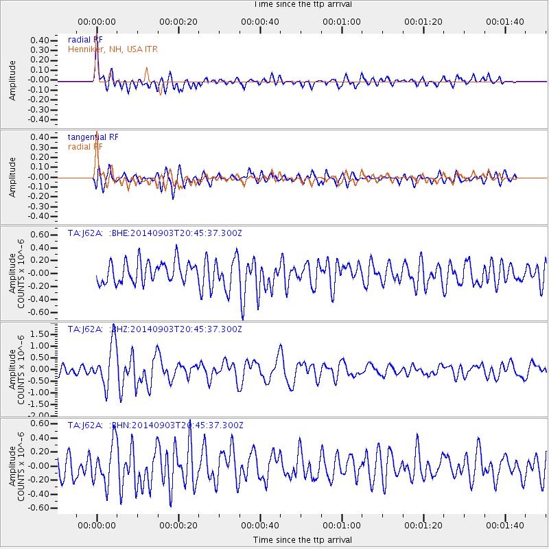
J62A Henniker, NH, USA - Earthquake Result Viewer
*The percent match for this event was below the threshold and hence no stack was calculated.
| Earthquake location: |
Easter Island Region |
| Earthquake latitude/longitude: |
-26.5/-114.6 |
| Earthquake time(UTC): |
2014/09/03 (246) 20:34:00 GMT |
| Earthquake Depth: |
10 km |
| Earthquake Magnitude: |
5.9 MWB |
| Earthquake Catalog/Contributor: |
NEIC PDE/NEIC COMCAT |
|
| Network: |
TA USArray Transportable Network (new EarthScope stations) |
| Station: |
J62A Henniker, NH, USA |
| Lat/Lon: |
43.23 N/71.81 W |
| Elevation: |
266 m |
|
| Distance: |
79.8 deg |
| Az: |
30.314 deg |
| Baz: |
218.21 deg |
| Ray Param: |
$rayparam |
*The percent match for this event was below the threshold and hence was not used in the summary stack. |
|
| Radial Match: |
73.647446 % |
| Radial Bump: |
400 |
| Transverse Match: |
71.33422 % |
| Transverse Bump: |
400 |
| SOD ConfigId: |
790520 |
| Insert Time: |
2014-09-17 21:21:08.308 +0000 |
| GWidth: |
2.5 |
| Max Bumps: |
400 |
| Tol: |
0.001 |
|
Signal To Noise
| Channel | StoN | STA | LTA |
| TA:J62A: :BHZ:20140903T20:45:37.300Z | 5.058775 | 9.4020066E-7 | 1.858554E-7 |
| TA:J62A: :BHN:20140903T20:45:37.300Z | 2.1212182 | 2.9653586E-7 | 1.3979508E-7 |
| TA:J62A: :BHE:20140903T20:45:37.300Z | 1.4985877 | 2.3656169E-7 | 1.5785642E-7 |
| Arrivals |
| Ps | |
| PpPs | |
| PsPs/PpSs | |


