You are here: Home > Network List > TA - USArray Transportable Network (new EarthScope stations) Stations List
> Station K55A Perry, NY, USA > Earthquake Result Viewer
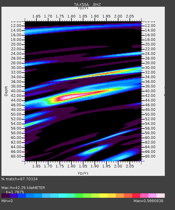
K55A Perry, NY, USA - Earthquake Result Viewer
| Earthquake location: |
Easter Island Region |
| Earthquake latitude/longitude: |
-26.5/-114.6 |
| Earthquake time(UTC): |
2014/09/03 (246) 20:34:00 GMT |
| Earthquake Depth: |
10 km |
| Earthquake Magnitude: |
5.9 MWB |
| Earthquake Catalog/Contributor: |
NEIC PDE/NEIC COMCAT |
|
| Network: |
TA USArray Transportable Network (new EarthScope stations) |
| Station: |
K55A Perry, NY, USA |
| Lat/Lon: |
42.73 N/78.07 W |
| Elevation: |
482 m |
|
| Distance: |
76.7 deg |
| Az: |
26.805 deg |
| Baz: |
213.244 deg |
| Ray Param: |
0.050801743 |
| Estimated Moho Depth: |
42.25 km |
| Estimated Crust Vp/Vs: |
1.80 |
| Assumed Crust Vp: |
6.419 km/s |
| Estimated Crust Vs: |
3.571 km/s |
| Estimated Crust Poisson's Ratio: |
0.28 |
|
| Radial Match: |
87.70334 % |
| Radial Bump: |
400 |
| Transverse Match: |
68.63511 % |
| Transverse Bump: |
400 |
| SOD ConfigId: |
790520 |
| Insert Time: |
2014-09-17 21:21:22.198 +0000 |
| GWidth: |
2.5 |
| Max Bumps: |
400 |
| Tol: |
0.001 |
|

Signal To Noise
| Channel | StoN | STA | LTA |
| TA:K55A: :BHZ:20140903T20:45:20.274976Z | 6.952162 | 8.9097773E-7 | 1.2815838E-7 |
| TA:K55A: :BHN:20140903T20:45:20.274976Z | 2.750716 | 2.9301904E-7 | 1.06524645E-7 |
| TA:K55A: :BHE:20140903T20:45:20.274976Z | 1.9161147 | 2.3428049E-7 | 1.2226852E-7 |
| Arrivals |
| Ps | 5.4 SECOND |
| PpPs | 18 SECOND |
| PsPs/PpSs | 23 SECOND |


