You are here: Home > Network List > TA - USArray Transportable Network (new EarthScope stations) Stations List
> Station L57A Andrews Acres Farm, Gillet, PA, USA > Earthquake Result Viewer
L57A Andrews Acres Farm, Gillet, PA, USA - Earthquake Result Viewer

| Earthquake location: |
Easter Island Region |
| Earthquake latitude/longitude: |
-26.5/-114.6 |
| Earthquake time(UTC): |
2014/09/03 (246) 20:34:00 GMT |
| Earthquake Depth: |
10 km |
| Earthquake Magnitude: |
5.9 MWB |
| Earthquake Catalog/Contributor: |
NEIC PDE/NEIC COMCAT |
|
| Network: |
TA USArray Transportable Network (new EarthScope stations) |
| Station: |
L57A Andrews Acres Farm, Gillet, PA, USA |
| Lat/Lon: |
42.00 N/76.85 W |
| Elevation: |
546 m |
|
| Distance: |
76.6 deg |
| Az: |
27.993 deg |
| Baz: |
214.337 deg |
| Ray Param: |
0.05086959 |
| Estimated Moho Depth: |
45.0 km |
| Estimated Crust Vp/Vs: |
1.74 |
| Assumed Crust Vp: |
6.476 km/s |
| Estimated Crust Vs: |
3.733 km/s |
| Estimated Crust Poisson's Ratio: |
0.25 |
|
| Radial Match: |
86.21018 % |
| Radial Bump: |
400 |
| Transverse Match: |
70.08487 % |
| Transverse Bump: |
400 |
| SOD ConfigId: |
790520 |
| Insert Time: |
2014-09-17 21:22:47.851 +0000 |
| GWidth: |
2.5 |
| Max Bumps: |
400 |
| Tol: |
0.001 |
|
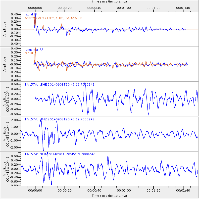
Signal To Noise
| Channel | StoN | STA | LTA |
| TA:L57A: :BHZ:20140903T20:45:19.700024Z | 5.3914766 | 1.0371473E-6 | 1.9236795E-7 |
| TA:L57A: :BHN:20140903T20:45:19.700024Z | 1.8588423 | 2.7083937E-7 | 1.4570325E-7 |
| TA:L57A: :BHE:20140903T20:45:19.700024Z | 3.0158093 | 3.3790687E-7 | 1.1204518E-7 |
| Arrivals |
| Ps | 5.3 SECOND |
| PpPs | 18 SECOND |
| PsPs/PpSs | 24 SECOND |


