You are here: Home > Network List > TA - USArray Transportable Network (new EarthScope stations) Stations List
> Station N58A Sunbury, PA, USA > Earthquake Result Viewer
N58A Sunbury, PA, USA - Earthquake Result Viewer
| Earthquake location: |
Easter Island Region |
| Earthquake latitude/longitude: |
-26.5/-114.6 |
| Earthquake time(UTC): |
2014/09/03 (246) 20:34:00 GMT |
| Earthquake Depth: |
10 km |
| Earthquake Magnitude: |
5.9 MWB |
| Earthquake Catalog/Contributor: |
NEIC PDE/NEIC COMCAT |
|
| Network: |
TA USArray Transportable Network (new EarthScope stations) |
| Station: |
N58A Sunbury, PA, USA |
| Lat/Lon: |
40.84 N/76.72 W |
| Elevation: |
200 m |
|
| Distance: |
75.7 deg |
| Az: |
28.754 deg |
| Baz: |
214.607 deg |
| Ray Param: |
0.051475763 |
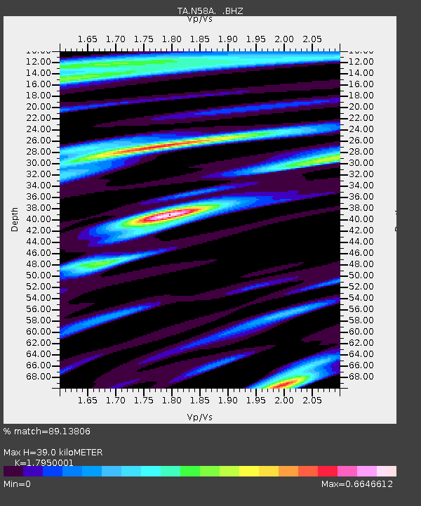
| Estimated Moho Depth: |
39.0 km |
| Estimated Crust Vp/Vs: |
1.80 |
| Assumed Crust Vp: |
6.121 km/s |
| Estimated Crust Vs: |
3.41 km/s |
| Estimated Crust Poisson's Ratio: |
0.27 |
|
| Radial Match: |
89.13806 % |
| Radial Bump: |
400 |
| Transverse Match: |
73.13661 % |
| Transverse Bump: |
400 |
| SOD ConfigId: |
790520 |
| Insert Time: |
2014-09-17 21:24:19.846 +0000 |
| GWidth: |
2.5 |
| Max Bumps: |
400 |
| Tol: |
0.001 |
|

Signal To Noise
| Channel | StoN | STA | LTA |
| TA:N58A: :BHZ:20140903T20:45:14.599988Z | 6.2902217 | 9.624837E-7 | 1.5301268E-7 |
| TA:N58A: :BHN:20140903T20:45:14.599988Z | 3.050972 | 2.9647535E-7 | 9.7174066E-8 |
| TA:N58A: :BHE:20140903T20:45:14.599988Z | 2.6492455 | 2.269659E-7 | 8.56719E-8 |
| Arrivals |
| Ps | 5.2 SECOND |
| PpPs | 17 SECOND |
| PsPs/PpSs | 23 SECOND |


