You are here: Home > Network List > TA - USArray Transportable Network (new EarthScope stations) Stations List
> Station P54A Burton, WV, USA > Earthquake Result Viewer
P54A Burton, WV, USA - Earthquake Result Viewer
| Earthquake location: |
Easter Island Region |
| Earthquake latitude/longitude: |
-26.5/-114.6 |
| Earthquake time(UTC): |
2014/09/03 (246) 20:34:00 GMT |
| Earthquake Depth: |
10 km |
| Earthquake Magnitude: |
5.9 MWB |
| Earthquake Catalog/Contributor: |
NEIC PDE/NEIC COMCAT |
|
| Network: |
TA USArray Transportable Network (new EarthScope stations) |
| Station: |
P54A Burton, WV, USA |
| Lat/Lon: |
39.61 N/80.48 W |
| Elevation: |
473 m |
|
| Distance: |
73.1 deg |
| Az: |
26.947 deg |
| Baz: |
211.7 deg |
| Ray Param: |
0.053213403 |
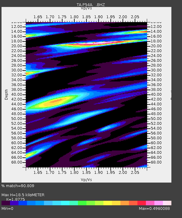
| Estimated Moho Depth: |
18.5 km |
| Estimated Crust Vp/Vs: |
1.88 |
| Assumed Crust Vp: |
6.207 km/s |
| Estimated Crust Vs: |
3.306 km/s |
| Estimated Crust Poisson's Ratio: |
0.30 |
|
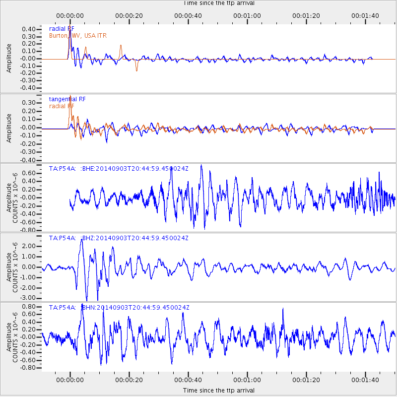
| Radial Match: |
90.809 % |
| Radial Bump: |
400 |
| Transverse Match: |
76.772125 % |
| Transverse Bump: |
400 |
| SOD ConfigId: |
790520 |
| Insert Time: |
2014-09-17 21:25:13.742 +0000 |
| GWidth: |
2.5 |
| Max Bumps: |
400 |
| Tol: |
0.001 |
|
Signal To Noise
| Channel | StoN | STA | LTA |
| TA:P54A: :BHZ:20140903T20:44:59.450024Z | 8.498257 | 1.2551649E-6 | 1.4769674E-7 |
| TA:P54A: :BHN:20140903T20:44:59.450024Z | 3.097272 | 3.450476E-7 | 1.11403715E-7 |
| TA:P54A: :BHE:20140903T20:44:59.450024Z | 2.7595775 | 3.3488212E-7 | 1.2135268E-7 |
| Arrivals |
| Ps | 2.7 SECOND |
| PpPs | 8.3 SECOND |
| PsPs/PpSs | 11 SECOND |


