You are here: Home > Network List > TA - USArray Transportable Network (new EarthScope stations) Stations List
> Station P59A Jarrettsville, MD, USA > Earthquake Result Viewer
P59A Jarrettsville, MD, USA - Earthquake Result Viewer

| Earthquake location: |
Easter Island Region |
| Earthquake latitude/longitude: |
-26.5/-114.6 |
| Earthquake time(UTC): |
2014/09/03 (246) 20:34:00 GMT |
| Earthquake Depth: |
10 km |
| Earthquake Magnitude: |
5.9 MWB |
| Earthquake Catalog/Contributor: |
NEIC PDE/NEIC COMCAT |
|
| Network: |
TA USArray Transportable Network (new EarthScope stations) |
| Station: |
P59A Jarrettsville, MD, USA |
| Lat/Lon: |
39.61 N/76.43 W |
| Elevation: |
157 m |
|
| Distance: |
74.8 deg |
| Az: |
29.663 deg |
| Baz: |
215.02 deg |
| Ray Param: |
0.052063532 |
| Estimated Moho Depth: |
25.25 km |
| Estimated Crust Vp/Vs: |
1.93 |
| Assumed Crust Vp: |
6.419 km/s |
| Estimated Crust Vs: |
3.317 km/s |
| Estimated Crust Poisson's Ratio: |
0.32 |
|
| Radial Match: |
91.0931 % |
| Radial Bump: |
390 |
| Transverse Match: |
77.67234 % |
| Transverse Bump: |
400 |
| SOD ConfigId: |
790520 |
| Insert Time: |
2014-09-17 21:25:25.817 +0000 |
| GWidth: |
2.5 |
| Max Bumps: |
400 |
| Tol: |
0.001 |
|
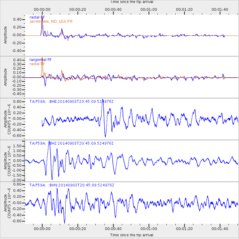
Signal To Noise
| Channel | StoN | STA | LTA |
| TA:P59A: :BHZ:20140903T20:45:09.524976Z | 13.548301 | 9.678563E-7 | 7.143747E-8 |
| TA:P59A: :BHN:20140903T20:45:09.524976Z | 3.5730486 | 2.234229E-7 | 6.253005E-8 |
| TA:P59A: :BHE:20140903T20:45:09.524976Z | 3.6308813 | 2.9117936E-7 | 8.019523E-8 |
| Arrivals |
| Ps | 3.8 SECOND |
| PpPs | 11 SECOND |
| PsPs/PpSs | 15 SECOND |


