You are here: Home > Network List > TA - USArray Transportable Network (new EarthScope stations) Stations List
> Station P60A Greenville, DE, USA > Earthquake Result Viewer
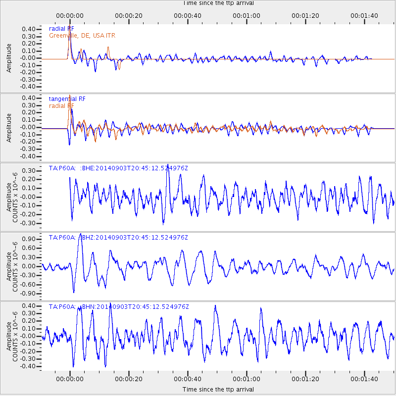
P60A Greenville, DE, USA - Earthquake Result Viewer
*The percent match for this event was below the threshold and hence no stack was calculated.
| Earthquake location: |
Easter Island Region |
| Earthquake latitude/longitude: |
-26.5/-114.6 |
| Earthquake time(UTC): |
2014/09/03 (246) 20:34:00 GMT |
| Earthquake Depth: |
10 km |
| Earthquake Magnitude: |
5.9 MWB |
| Earthquake Catalog/Contributor: |
NEIC PDE/NEIC COMCAT |
|
| Network: |
TA USArray Transportable Network (new EarthScope stations) |
| Station: |
P60A Greenville, DE, USA |
| Lat/Lon: |
39.81 N/75.64 W |
| Elevation: |
105 m |
|
| Distance: |
75.4 deg |
| Az: |
30.062 deg |
| Baz: |
215.63 deg |
| Ray Param: |
$rayparam |
*The percent match for this event was below the threshold and hence was not used in the summary stack. |
|
| Radial Match: |
76.65246 % |
| Radial Bump: |
400 |
| Transverse Match: |
62.766624 % |
| Transverse Bump: |
400 |
| SOD ConfigId: |
790520 |
| Insert Time: |
2014-09-17 21:25:28.136 +0000 |
| GWidth: |
2.5 |
| Max Bumps: |
400 |
| Tol: |
0.001 |
|
Signal To Noise
| Channel | StoN | STA | LTA |
| TA:P60A: :BHZ:20140903T20:45:12.524976Z | 6.919773 | 5.672031E-7 | 8.196845E-8 |
| TA:P60A: :BHN:20140903T20:45:12.524976Z | 3.9603658 | 2.391565E-7 | 6.038747E-8 |
| TA:P60A: :BHE:20140903T20:45:12.524976Z | 1.884261 | 1.7785557E-7 | 9.439009E-8 |
| Arrivals |
| Ps | |
| PpPs | |
| PsPs/PpSs | |


