You are here: Home > Network List > TA - USArray Transportable Network (new EarthScope stations) Stations List
> Station Q54A Coxs Mills, WV, USA > Earthquake Result Viewer
Q54A Coxs Mills, WV, USA - Earthquake Result Viewer

| Earthquake location: |
Easter Island Region |
| Earthquake latitude/longitude: |
-26.5/-114.6 |
| Earthquake time(UTC): |
2014/09/03 (246) 20:34:00 GMT |
| Earthquake Depth: |
10 km |
| Earthquake Magnitude: |
5.9 MWB |
| Earthquake Catalog/Contributor: |
NEIC PDE/NEIC COMCAT |
|
| Network: |
TA USArray Transportable Network (new EarthScope stations) |
| Station: |
Q54A Coxs Mills, WV, USA |
| Lat/Lon: |
38.98 N/80.83 W |
| Elevation: |
254 m |
|
| Distance: |
72.4 deg |
| Az: |
27.045 deg |
| Baz: |
211.505 deg |
| Ray Param: |
0.053656455 |
| Estimated Moho Depth: |
36.75 km |
| Estimated Crust Vp/Vs: |
1.72 |
| Assumed Crust Vp: |
6.207 km/s |
| Estimated Crust Vs: |
3.603 km/s |
| Estimated Crust Poisson's Ratio: |
0.25 |
|
| Radial Match: |
88.3213 % |
| Radial Bump: |
400 |
| Transverse Match: |
66.052635 % |
| Transverse Bump: |
398 |
| SOD ConfigId: |
790520 |
| Insert Time: |
2014-09-17 21:25:42.138 +0000 |
| GWidth: |
2.5 |
| Max Bumps: |
400 |
| Tol: |
0.001 |
|
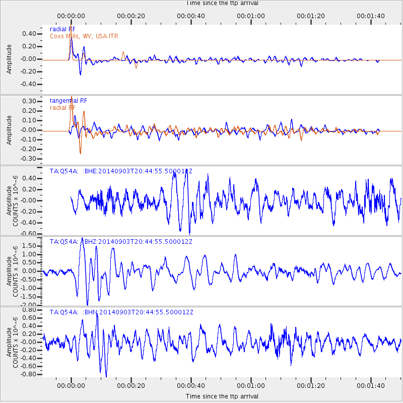
Signal To Noise
| Channel | StoN | STA | LTA |
| TA:Q54A: :BHZ:20140903T20:44:55.500012Z | 9.6180935 | 9.885778E-7 | 1.0278313E-7 |
| TA:Q54A: :BHN:20140903T20:44:55.500012Z | 2.845099 | 2.671802E-7 | 9.390893E-8 |
| TA:Q54A: :BHE:20140903T20:44:55.500012Z | 2.303459 | 2.7122877E-7 | 1.1774847E-7 |
| Arrivals |
| Ps | 4.4 SECOND |
| PpPs | 16 SECOND |
| PsPs/PpSs | 20 SECOND |


