You are here: Home > Network List > TA - USArray Transportable Network (new EarthScope stations) Stations List
> Station Q58A Fox Den Farm, The Plains, VA, USA > Earthquake Result Viewer
Q58A Fox Den Farm, The Plains, VA, USA - Earthquake Result Viewer

| Earthquake location: |
Easter Island Region |
| Earthquake latitude/longitude: |
-26.5/-114.6 |
| Earthquake time(UTC): |
2014/09/03 (246) 20:34:00 GMT |
| Earthquake Depth: |
10 km |
| Earthquake Magnitude: |
5.9 MWB |
| Earthquake Catalog/Contributor: |
NEIC PDE/NEIC COMCAT |
|
| Network: |
TA USArray Transportable Network (new EarthScope stations) |
| Station: |
Q58A Fox Den Farm, The Plains, VA, USA |
| Lat/Lon: |
38.94 N/77.68 W |
| Elevation: |
182 m |
|
| Distance: |
73.7 deg |
| Az: |
29.227 deg |
| Baz: |
214.114 deg |
| Ray Param: |
0.052803166 |
| Estimated Moho Depth: |
35.0 km |
| Estimated Crust Vp/Vs: |
1.66 |
| Assumed Crust Vp: |
6.419 km/s |
| Estimated Crust Vs: |
3.861 km/s |
| Estimated Crust Poisson's Ratio: |
0.22 |
|
| Radial Match: |
88.66782 % |
| Radial Bump: |
400 |
| Transverse Match: |
74.22417 % |
| Transverse Bump: |
400 |
| SOD ConfigId: |
790520 |
| Insert Time: |
2014-09-17 21:25:52.409 +0000 |
| GWidth: |
2.5 |
| Max Bumps: |
400 |
| Tol: |
0.001 |
|
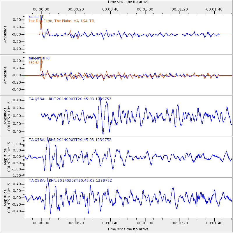
Signal To Noise
| Channel | StoN | STA | LTA |
| TA:Q58A: :BHZ:20140903T20:45:03.123975Z | 9.0149975 | 7.4083255E-7 | 8.2177785E-8 |
| TA:Q58A: :BHN:20140903T20:45:03.123975Z | 5.551222 | 2.6648527E-7 | 4.8004797E-8 |
| TA:Q58A: :BHE:20140903T20:45:03.123975Z | 2.6992595 | 2.2328119E-7 | 8.2719424E-8 |
| Arrivals |
| Ps | 3.7 SECOND |
| PpPs | 14 SECOND |
| PsPs/PpSs | 18 SECOND |


