You are here: Home > Network List > TA - USArray Transportable Network (new EarthScope stations) Stations List
> Station R59A King George, VA, USA > Earthquake Result Viewer
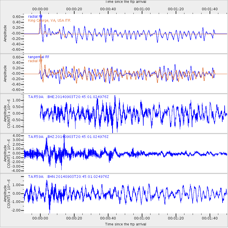
R59A King George, VA, USA - Earthquake Result Viewer
*The percent match for this event was below the threshold and hence no stack was calculated.
| Earthquake location: |
Easter Island Region |
| Earthquake latitude/longitude: |
-26.5/-114.6 |
| Earthquake time(UTC): |
2014/09/03 (246) 20:34:00 GMT |
| Earthquake Depth: |
10 km |
| Earthquake Magnitude: |
5.9 MWB |
| Earthquake Catalog/Contributor: |
NEIC PDE/NEIC COMCAT |
|
| Network: |
TA USArray Transportable Network (new EarthScope stations) |
| Station: |
R59A King George, VA, USA |
| Lat/Lon: |
38.20 N/77.12 W |
| Elevation: |
35 m |
|
| Distance: |
73.4 deg |
| Az: |
30.045 deg |
| Baz: |
214.697 deg |
| Ray Param: |
$rayparam |
*The percent match for this event was below the threshold and hence was not used in the summary stack. |
|
| Radial Match: |
74.36394 % |
| Radial Bump: |
400 |
| Transverse Match: |
63.761944 % |
| Transverse Bump: |
400 |
| SOD ConfigId: |
790520 |
| Insert Time: |
2014-09-17 21:26:17.617 +0000 |
| GWidth: |
2.5 |
| Max Bumps: |
400 |
| Tol: |
0.001 |
|
Signal To Noise
| Channel | StoN | STA | LTA |
| TA:R59A: :BHZ:20140903T20:45:01.024976Z | 2.2811346 | 1.0396636E-6 | 4.55766E-7 |
| TA:R59A: :BHN:20140903T20:45:01.024976Z | 1.5187987 | 6.289319E-7 | 4.1409825E-7 |
| TA:R59A: :BHE:20140903T20:45:01.024976Z | 1.4581865 | 5.1918886E-7 | 3.5605106E-7 |
| Arrivals |
| Ps | |
| PpPs | |
| PsPs/PpSs | |


