You are here: Home > Network List > TA - USArray Transportable Network (new EarthScope stations) Stations List
> Station S57A Dark Hollow, Roseland, VA, USA > Earthquake Result Viewer
S57A Dark Hollow, Roseland, VA, USA - Earthquake Result Viewer
| Earthquake location: |
Easter Island Region |
| Earthquake latitude/longitude: |
-26.5/-114.6 |
| Earthquake time(UTC): |
2014/09/03 (246) 20:34:00 GMT |
| Earthquake Depth: |
10 km |
| Earthquake Magnitude: |
5.9 MWB |
| Earthquake Catalog/Contributor: |
NEIC PDE/NEIC COMCAT |
|
| Network: |
TA USArray Transportable Network (new EarthScope stations) |
| Station: |
S57A Dark Hollow, Roseland, VA, USA |
| Lat/Lon: |
37.76 N/78.95 W |
| Elevation: |
264 m |
|
| Distance: |
72.2 deg |
| Az: |
29.041 deg |
| Baz: |
213.274 deg |
| Ray Param: |
0.05381633 |
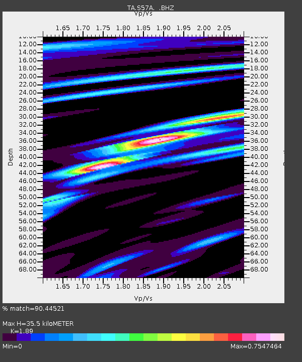
| Estimated Moho Depth: |
35.5 km |
| Estimated Crust Vp/Vs: |
1.89 |
| Assumed Crust Vp: |
6.419 km/s |
| Estimated Crust Vs: |
3.396 km/s |
| Estimated Crust Poisson's Ratio: |
0.31 |
|
| Radial Match: |
90.44521 % |
| Radial Bump: |
392 |
| Transverse Match: |
85.987564 % |
| Transverse Bump: |
400 |
| SOD ConfigId: |
790520 |
| Insert Time: |
2014-09-17 21:26:36.952 +0000 |
| GWidth: |
2.5 |
| Max Bumps: |
400 |
| Tol: |
0.001 |
|

Signal To Noise
| Channel | StoN | STA | LTA |
| TA:S57A: :BHZ:20140903T20:44:54.075024Z | 11.070993 | 7.4952897E-7 | 6.770205E-8 |
| TA:S57A: :BHN:20140903T20:44:54.075024Z | 4.397314 | 2.3809125E-7 | 5.41447E-8 |
| TA:S57A: :BHE:20140903T20:44:54.075024Z | 2.3646426 | 1.8430117E-7 | 7.794039E-8 |
| Arrivals |
| Ps | 5.1 SECOND |
| PpPs | 15 SECOND |
| PsPs/PpSs | 21 SECOND |


