You are here: Home > Network List > TA - USArray Transportable Network (new EarthScope stations) Stations List
> Station T59A Double 'B' Farms, VA, USA > Earthquake Result Viewer
T59A Double 'B' Farms, VA, USA - Earthquake Result Viewer

| Earthquake location: |
Easter Island Region |
| Earthquake latitude/longitude: |
-26.5/-114.6 |
| Earthquake time(UTC): |
2014/09/03 (246) 20:34:00 GMT |
| Earthquake Depth: |
10 km |
| Earthquake Magnitude: |
5.9 MWB |
| Earthquake Catalog/Contributor: |
NEIC PDE/NEIC COMCAT |
|
| Network: |
TA USArray Transportable Network (new EarthScope stations) |
| Station: |
T59A Double 'B' Farms, VA, USA |
| Lat/Lon: |
36.97 N/77.55 W |
| Elevation: |
63 m |
|
| Distance: |
72.2 deg |
| Az: |
30.475 deg |
| Baz: |
214.558 deg |
| Ray Param: |
0.05383726 |
| Estimated Moho Depth: |
37.5 km |
| Estimated Crust Vp/Vs: |
1.62 |
| Assumed Crust Vp: |
6.565 km/s |
| Estimated Crust Vs: |
4.065 km/s |
| Estimated Crust Poisson's Ratio: |
0.19 |
|
| Radial Match: |
83.16433 % |
| Radial Bump: |
400 |
| Transverse Match: |
77.67024 % |
| Transverse Bump: |
400 |
| SOD ConfigId: |
790520 |
| Insert Time: |
2014-09-17 21:27:12.311 +0000 |
| GWidth: |
2.5 |
| Max Bumps: |
400 |
| Tol: |
0.001 |
|
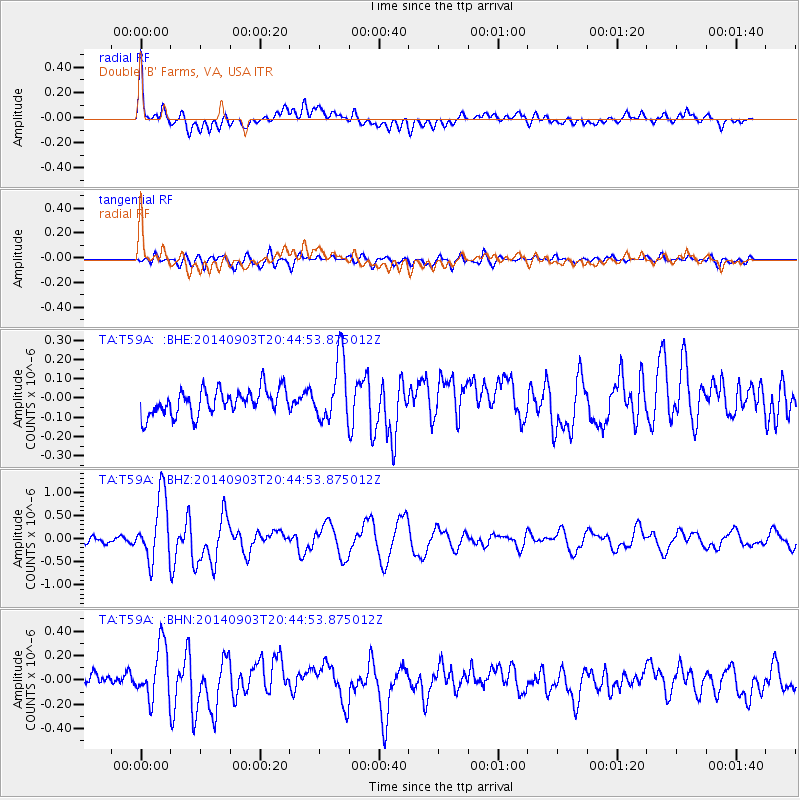
Signal To Noise
| Channel | StoN | STA | LTA |
| TA:T59A: :BHZ:20140903T20:44:53.875012Z | 10.417308 | 7.012555E-7 | 6.7316385E-8 |
| TA:T59A: :BHN:20140903T20:44:53.875012Z | 3.1580472 | 2.3131007E-7 | 7.324465E-8 |
| TA:T59A: :BHE:20140903T20:44:53.875012Z | 2.4482977 | 1.6430307E-7 | 6.710911E-8 |
| Arrivals |
| Ps | 3.7 SECOND |
| PpPs | 14 SECOND |
| PsPs/PpSs | 18 SECOND |


