You are here: Home > Network List > TA - USArray Transportable Network (new EarthScope stations) Stations List
> Station W59A Clinton, NC, USA > Earthquake Result Viewer
W59A Clinton, NC, USA - Earthquake Result Viewer
| Earthquake location: |
Easter Island Region |
| Earthquake latitude/longitude: |
-26.5/-114.6 |
| Earthquake time(UTC): |
2014/09/03 (246) 20:34:00 GMT |
| Earthquake Depth: |
10 km |
| Earthquake Magnitude: |
5.9 MWB |
| Earthquake Catalog/Contributor: |
NEIC PDE/NEIC COMCAT |
|
| Network: |
TA USArray Transportable Network (new EarthScope stations) |
| Station: |
W59A Clinton, NC, USA |
| Lat/Lon: |
35.17 N/78.44 W |
| Elevation: |
60 m |
|
| Distance: |
70.3 deg |
| Az: |
30.92 deg |
| Baz: |
214.18 deg |
| Ray Param: |
0.055087857 |
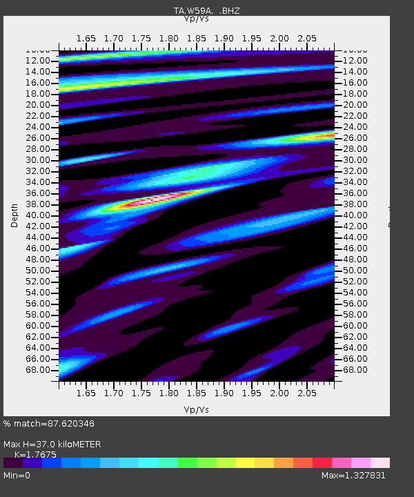
| Estimated Moho Depth: |
37.0 km |
| Estimated Crust Vp/Vs: |
1.77 |
| Assumed Crust Vp: |
6.565 km/s |
| Estimated Crust Vs: |
3.714 km/s |
| Estimated Crust Poisson's Ratio: |
0.26 |
|
| Radial Match: |
87.620346 % |
| Radial Bump: |
400 |
| Transverse Match: |
57.533016 % |
| Transverse Bump: |
400 |
| SOD ConfigId: |
790520 |
| Insert Time: |
2014-09-17 21:28:21.451 +0000 |
| GWidth: |
2.5 |
| Max Bumps: |
400 |
| Tol: |
0.001 |
|

Signal To Noise
| Channel | StoN | STA | LTA |
| TA:W59A: :BHZ:20140903T20:44:42.450024Z | 3.1641665 | 9.197113E-7 | 2.9066464E-7 |
| TA:W59A: :BHN:20140903T20:44:42.450024Z | 1.7623802 | 4.3219873E-7 | 2.4523578E-7 |
| TA:W59A: :BHE:20140903T20:44:42.450024Z | 1.2187864 | 2.8158783E-7 | 2.3103952E-7 |
| Arrivals |
| Ps | 4.5 SECOND |
| PpPs | 15 SECOND |
| PsPs/PpSs | 20 SECOND |


