You are here: Home > Network List > TA - USArray Transportable Network (new EarthScope stations) Stations List
> Station X55A Gracelyn & Ava, Whitmire, SC, USA > Earthquake Result Viewer
X55A Gracelyn & Ava, Whitmire, SC, USA - Earthquake Result Viewer
| Earthquake location: |
Easter Island Region |
| Earthquake latitude/longitude: |
-26.5/-114.6 |
| Earthquake time(UTC): |
2014/09/03 (246) 20:34:00 GMT |
| Earthquake Depth: |
10 km |
| Earthquake Magnitude: |
5.9 MWB |
| Earthquake Catalog/Contributor: |
NEIC PDE/NEIC COMCAT |
|
| Network: |
TA USArray Transportable Network (new EarthScope stations) |
| Station: |
X55A Gracelyn & Ava, Whitmire, SC, USA |
| Lat/Lon: |
34.47 N/81.63 W |
| Elevation: |
153 m |
|
| Distance: |
68.3 deg |
| Az: |
28.969 deg |
| Baz: |
211.676 deg |
| Ray Param: |
0.056414332 |
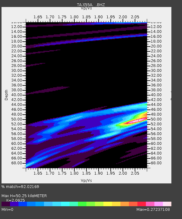
| Estimated Moho Depth: |
50.25 km |
| Estimated Crust Vp/Vs: |
2.06 |
| Assumed Crust Vp: |
6.419 km/s |
| Estimated Crust Vs: |
3.112 km/s |
| Estimated Crust Poisson's Ratio: |
0.35 |
|
| Radial Match: |
92.02169 % |
| Radial Bump: |
400 |
| Transverse Match: |
54.677765 % |
| Transverse Bump: |
400 |
| SOD ConfigId: |
790520 |
| Insert Time: |
2014-09-17 21:28:37.475 +0000 |
| GWidth: |
2.5 |
| Max Bumps: |
400 |
| Tol: |
0.001 |
|

Signal To Noise
| Channel | StoN | STA | LTA |
| TA:X55A: :BHZ:20140903T20:44:30.024976Z | 17.74029 | 8.3167646E-7 | 4.688066E-8 |
| TA:X55A: :BHN:20140903T20:44:30.024976Z | 6.1368585 | 2.9253138E-7 | 4.7667935E-8 |
| TA:X55A: :BHE:20140903T20:44:30.024976Z | 3.139356 | 1.8937473E-7 | 6.03228E-8 |
| Arrivals |
| Ps | 8.6 SECOND |
| PpPs | 23 SECOND |
| PsPs/PpSs | 32 SECOND |


