You are here: Home > Network List > TA - USArray Transportable Network (new EarthScope stations) Stations List
> Station Y60A Bolivia, NC, USA > Earthquake Result Viewer
Y60A Bolivia, NC, USA - Earthquake Result Viewer

| Earthquake location: |
Easter Island Region |
| Earthquake latitude/longitude: |
-26.5/-114.6 |
| Earthquake time(UTC): |
2014/09/03 (246) 20:34:00 GMT |
| Earthquake Depth: |
10 km |
| Earthquake Magnitude: |
5.9 MWB |
| Earthquake Catalog/Contributor: |
NEIC PDE/NEIC COMCAT |
|
| Network: |
TA USArray Transportable Network (new EarthScope stations) |
| Station: |
Y60A Bolivia, NC, USA |
| Lat/Lon: |
34.00 N/78.22 W |
| Elevation: |
7.0 m |
|
| Distance: |
69.4 deg |
| Az: |
31.783 deg |
| Baz: |
214.606 deg |
| Ray Param: |
0.055653892 |
| Estimated Moho Depth: |
49.25 km |
| Estimated Crust Vp/Vs: |
1.64 |
| Assumed Crust Vp: |
6.565 km/s |
| Estimated Crust Vs: |
4.003 km/s |
| Estimated Crust Poisson's Ratio: |
0.20 |
|
| Radial Match: |
82.68921 % |
| Radial Bump: |
400 |
| Transverse Match: |
61.158142 % |
| Transverse Bump: |
400 |
| SOD ConfigId: |
790520 |
| Insert Time: |
2014-09-17 21:29:03.676 +0000 |
| GWidth: |
2.5 |
| Max Bumps: |
400 |
| Tol: |
0.001 |
|
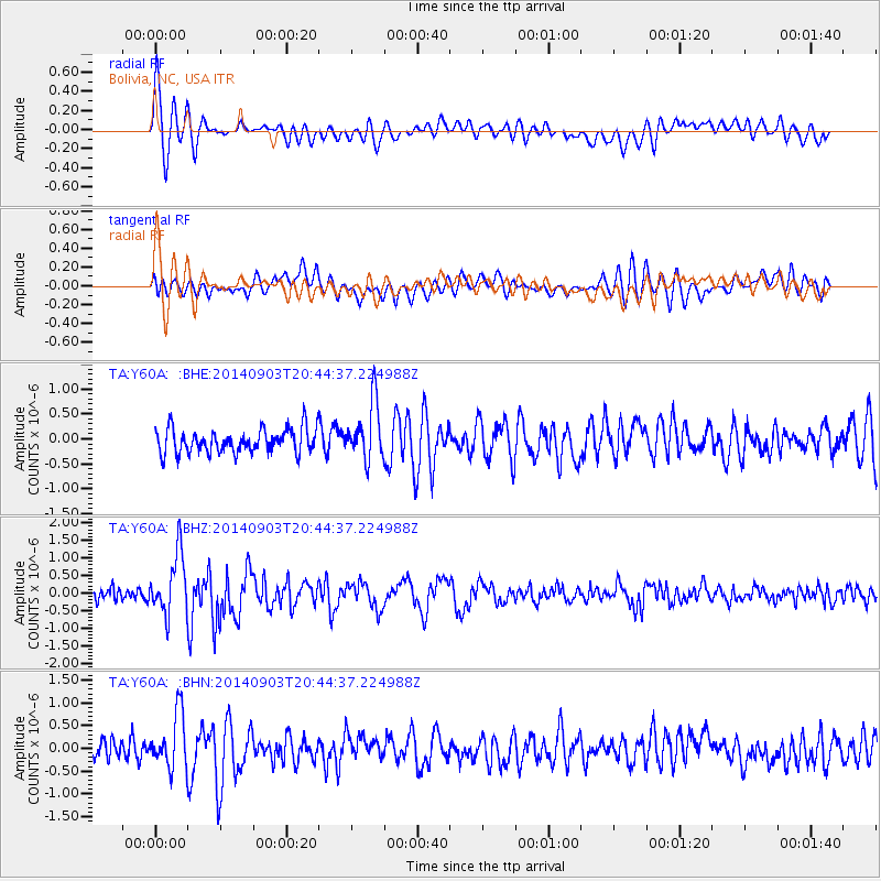
Signal To Noise
| Channel | StoN | STA | LTA |
| TA:Y60A: :BHZ:20140903T20:44:37.224988Z | 5.2898545 | 8.5551466E-7 | 1.6172744E-7 |
| TA:Y60A: :BHN:20140903T20:44:37.224988Z | 2.74353 | 5.9996097E-7 | 2.1868212E-7 |
| TA:Y60A: :BHE:20140903T20:44:37.224988Z | 2.3483572 | 5.666077E-7 | 2.4127831E-7 |
| Arrivals |
| Ps | 5.0 SECOND |
| PpPs | 19 SECOND |
| PsPs/PpSs | 24 SECOND |


