You are here: Home > Network List > TA - USArray Transportable Network (new EarthScope stations) Stations List
> Station Z59A Georgetown, SC, USA > Earthquake Result Viewer
Z59A Georgetown, SC, USA - Earthquake Result Viewer
| Earthquake location: |
Easter Island Region |
| Earthquake latitude/longitude: |
-26.5/-114.6 |
| Earthquake time(UTC): |
2014/09/03 (246) 20:34:00 GMT |
| Earthquake Depth: |
10 km |
| Earthquake Magnitude: |
5.9 MWB |
| Earthquake Catalog/Contributor: |
NEIC PDE/NEIC COMCAT |
|
| Network: |
TA USArray Transportable Network (new EarthScope stations) |
| Station: |
Z59A Georgetown, SC, USA |
| Lat/Lon: |
33.24 N/79.28 W |
| Elevation: |
8.0 m |
|
| Distance: |
68.3 deg |
| Az: |
31.457 deg |
| Baz: |
213.903 deg |
| Ray Param: |
0.056393743 |
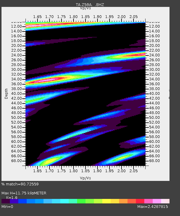
| Estimated Moho Depth: |
11.75 km |
| Estimated Crust Vp/Vs: |
1.60 |
| Assumed Crust Vp: |
6.24 km/s |
| Estimated Crust Vs: |
3.9 km/s |
| Estimated Crust Poisson's Ratio: |
0.18 |
|
| Radial Match: |
90.72559 % |
| Radial Bump: |
400 |
| Transverse Match: |
78.88812 % |
| Transverse Bump: |
400 |
| SOD ConfigId: |
790520 |
| Insert Time: |
2014-09-17 21:29:15.945 +0000 |
| GWidth: |
2.5 |
| Max Bumps: |
400 |
| Tol: |
0.001 |
|
Signal To Noise
| Channel | StoN | STA | LTA |
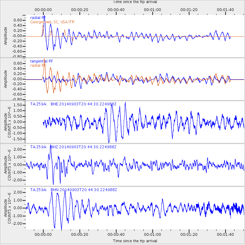
| TA:Z59A: :BHZ:20140903T20:44:30.224988Z | 4.760238 | 1.0742677E-6 | 2.2567522E-7 |
| TA:Z59A: :BHN:20140903T20:44:30.224988Z | 2.8839247 | 8.017954E-7 | 2.7802233E-7 |
| TA:Z59A: :BHE:20140903T20:44:30.224988Z | 1.810334 | 5.7045804E-7 | 3.1511203E-7 |
| Arrivals |
| Ps | 1.2 SECOND |
| PpPs | 4.7 SECOND |
| PsPs/PpSs | 5.9 SECOND |


