You are here: Home > Network List > US - United States National Seismic Network Stations List
> Station DGMT Dagmar, Montana, USA > Earthquake Result Viewer
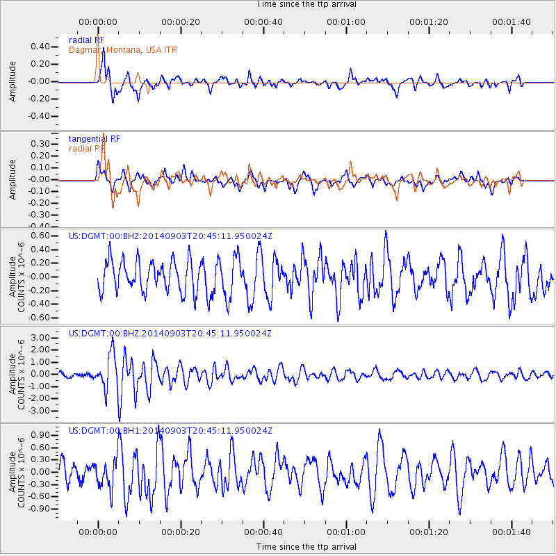
DGMT Dagmar, Montana, USA - Earthquake Result Viewer
*The percent match for this event was below the threshold and hence no stack was calculated.
| Earthquake location: |
Easter Island Region |
| Earthquake latitude/longitude: |
-26.5/-114.6 |
| Earthquake time(UTC): |
2014/09/03 (246) 20:34:00 GMT |
| Earthquake Depth: |
10 km |
| Earthquake Magnitude: |
5.9 MWB |
| Earthquake Catalog/Contributor: |
NEIC PDE/NEIC COMCAT |
|
| Network: |
US United States National Seismic Network |
| Station: |
DGMT Dagmar, Montana, USA |
| Lat/Lon: |
48.47 N/104.20 W |
| Elevation: |
0.0 m |
|
| Distance: |
75.3 deg |
| Az: |
7.159 deg |
| Baz: |
189.656 deg |
| Ray Param: |
$rayparam |
*The percent match for this event was below the threshold and hence was not used in the summary stack. |
|
| Radial Match: |
78.92085 % |
| Radial Bump: |
400 |
| Transverse Match: |
59.733303 % |
| Transverse Bump: |
400 |
| SOD ConfigId: |
790520 |
| Insert Time: |
2014-09-17 21:30:20.060 +0000 |
| GWidth: |
2.5 |
| Max Bumps: |
400 |
| Tol: |
0.001 |
|
Signal To Noise
| Channel | StoN | STA | LTA |
| US:DGMT:00:BHZ:20140903T20:45:11.950024Z | 10.919175 | 1.4545977E-6 | 1.3321498E-7 |
| US:DGMT:00:BH1:20140903T20:45:11.950024Z | 1.6138548 | 3.5761084E-7 | 2.2158798E-7 |
| US:DGMT:00:BH2:20140903T20:45:11.950024Z | 1.3890398 | 3.0528167E-7 | 2.1977894E-7 |
| Arrivals |
| Ps | |
| PpPs | |
| PsPs/PpSs | |


