You are here: Home > Network List > TA - USArray Transportable Network (new EarthScope stations) Stations List
> Station 121A Cookes Peak, Deming, NM, USA > Earthquake Result Viewer
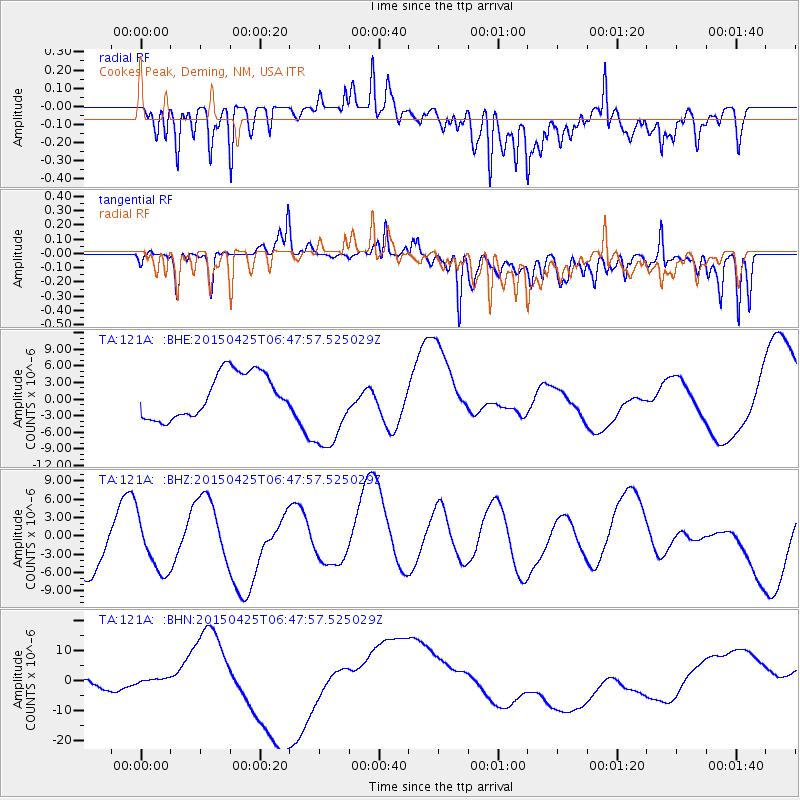
121A Cookes Peak, Deming, NM, USA - Earthquake Result Viewer
*The percent match for this event was below the threshold and hence no stack was calculated.
| Earthquake location: |
Southeast Of Honshu, Japan |
| Earthquake latitude/longitude: |
32.9/140.5 |
| Earthquake time(UTC): |
2015/04/25 (115) 06:35:46 GMT |
| Earthquake Depth: |
89 km |
| Earthquake Magnitude: |
5.2 mb, 5.2 mb |
| Earthquake Catalog/Contributor: |
ISC/ISC |
|
| Network: |
TA USArray Transportable Network (new EarthScope stations) |
| Station: |
121A Cookes Peak, Deming, NM, USA |
| Lat/Lon: |
32.53 N/107.79 W |
| Elevation: |
1652 m |
|
| Distance: |
88.5 deg |
| Az: |
51.714 deg |
| Baz: |
308.563 deg |
| Ray Param: |
$rayparam |
*The percent match for this event was below the threshold and hence was not used in the summary stack. |
|
| Radial Match: |
38.435143 % |
| Radial Bump: |
400 |
| Transverse Match: |
42.1155 % |
| Transverse Bump: |
400 |
| SOD ConfigId: |
7422571 |
| Insert Time: |
2019-04-18 09:04:16.698 +0000 |
| GWidth: |
2.5 |
| Max Bumps: |
400 |
| Tol: |
0.001 |
|
Signal To Noise
| Channel | StoN | STA | LTA |
| TA:121A: :BHZ:20150425T06:47:57.525029Z | 1.1471971 | 4.5898796E-6 | 4.000951E-6 |
| TA:121A: :BHN:20150425T06:47:57.525029Z | 0.21232 | 9.899734E-7 | 4.662648E-6 |
| TA:121A: :BHE:20150425T06:47:57.525029Z | 1.9726262 | 7.868263E-6 | 3.988725E-6 |
| Arrivals |
| Ps | |
| PpPs | |
| PsPs/PpSs | |


