You are here: Home > Network List > TA - USArray Transportable Network (new EarthScope stations) Stations List
> Station Z41A Richland Creek Farm, El Dorado, AR, USA > Earthquake Result Viewer
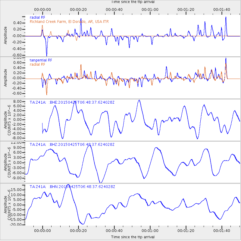
Z41A Richland Creek Farm, El Dorado, AR, USA - Earthquake Result Viewer
*The percent match for this event was below the threshold and hence no stack was calculated.
| Earthquake location: |
Southeast Of Honshu, Japan |
| Earthquake latitude/longitude: |
32.9/140.5 |
| Earthquake time(UTC): |
2015/04/25 (115) 06:35:46 GMT |
| Earthquake Depth: |
89 km |
| Earthquake Magnitude: |
5.2 mb, 5.2 mb |
| Earthquake Catalog/Contributor: |
ISC/ISC |
|
| Network: |
TA USArray Transportable Network (new EarthScope stations) |
| Station: |
Z41A Richland Creek Farm, El Dorado, AR, USA |
| Lat/Lon: |
33.26 N/92.80 W |
| Elevation: |
62 m |
|
| Distance: |
97.3 deg |
| Az: |
42.618 deg |
| Baz: |
317.156 deg |
| Ray Param: |
$rayparam |
*The percent match for this event was below the threshold and hence was not used in the summary stack. |
|
| Radial Match: |
66.28771 % |
| Radial Bump: |
358 |
| Transverse Match: |
58.76344 % |
| Transverse Bump: |
400 |
| SOD ConfigId: |
7422571 |
| Insert Time: |
2019-04-18 09:04:48.179 +0000 |
| GWidth: |
2.5 |
| Max Bumps: |
400 |
| Tol: |
0.001 |
|
Signal To Noise
| Channel | StoN | STA | LTA |
| TA:Z41A: :BHZ:20150425T06:48:37.624028Z | 2.5434527 | 9.247024E-6 | 3.6356184E-6 |
| TA:Z41A: :BHN:20150425T06:48:37.624028Z | 3.1454763 | 1.5086191E-5 | 4.796155E-6 |
| TA:Z41A: :BHE:20150425T06:48:37.624028Z | 0.53024167 | 2.2353283E-6 | 4.215678E-6 |
| Arrivals |
| Ps | |
| PpPs | |
| PsPs/PpSs | |


