You are here: Home > Network List > UU - University of Utah Regional Network Stations List
> Station TMU Trail Mountain (BB), UT, USA > Earthquake Result Viewer
TMU Trail Mountain (BB), UT, USA - Earthquake Result Viewer
| Earthquake location: |
Easter Island Region |
| Earthquake latitude/longitude: |
-26.5/-114.6 |
| Earthquake time(UTC): |
2014/09/03 (246) 20:34:00 GMT |
| Earthquake Depth: |
10 km |
| Earthquake Magnitude: |
5.9 MWB |
| Earthquake Catalog/Contributor: |
NEIC PDE/NEIC COMCAT |
|
| Network: |
UU University of Utah Regional Network |
| Station: |
TMU Trail Mountain (BB), UT, USA |
| Lat/Lon: |
39.30 N/111.21 W |
| Elevation: |
2731 m |
|
| Distance: |
65.6 deg |
| Az: |
2.914 deg |
| Baz: |
183.365 deg |
| Ray Param: |
0.05817824 |
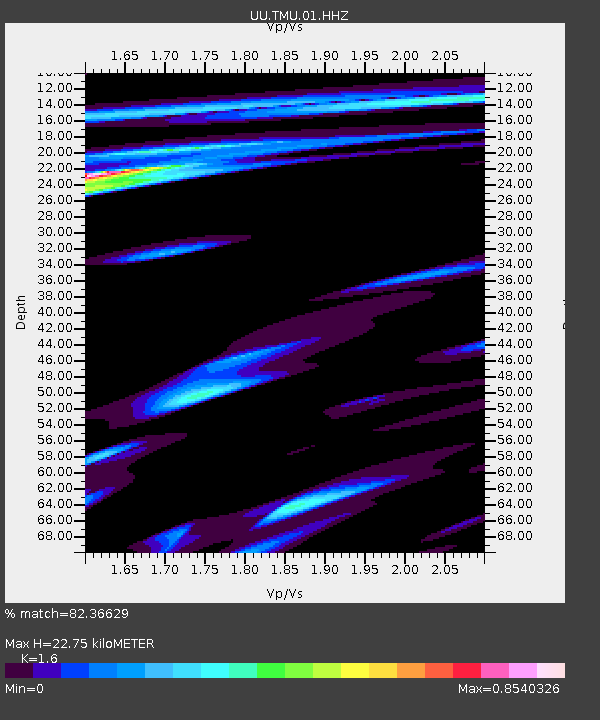
| Estimated Moho Depth: |
22.75 km |
| Estimated Crust Vp/Vs: |
1.60 |
| Assumed Crust Vp: |
6.207 km/s |
| Estimated Crust Vs: |
3.879 km/s |
| Estimated Crust Poisson's Ratio: |
0.18 |
|
| Radial Match: |
82.36629 % |
| Radial Bump: |
400 |
| Transverse Match: |
64.60277 % |
| Transverse Bump: |
400 |
| SOD ConfigId: |
790520 |
| Insert Time: |
2014-09-17 21:33:44.839 +0000 |
| GWidth: |
2.5 |
| Max Bumps: |
400 |
| Tol: |
0.001 |
|

Signal To Noise
| Channel | StoN | STA | LTA |
| UU:TMU:01:HHZ:20140903T20:44:12.950024Z | 15.939453 | 3.7913384E-8 | 2.3785873E-9 |
| UU:TMU:01:HHN:20140903T20:44:12.950024Z | 4.526893 | 1.3412452E-8 | 2.9628382E-9 |
| UU:TMU:01:HHE:20140903T20:44:12.950024Z | 0.87281686 | 3.414463E-9 | 3.912004E-9 |
| Arrivals |
| Ps | 2.3 SECOND |
| PpPs | 9.1 SECOND |
| PsPs/PpSs | 11 SECOND |


