You are here: Home > Network List > AK - Alaska Regional Network Stations List
> Station BRSE Bradley Lake South, AK, USA > Earthquake Result Viewer
BRSE Bradley Lake South, AK, USA - Earthquake Result Viewer
| Earthquake location: |
Tonga Islands |
| Earthquake latitude/longitude: |
-21.4/-173.3 |
| Earthquake time(UTC): |
2014/09/04 (247) 05:33:46 GMT |
| Earthquake Depth: |
12 km |
| Earthquake Magnitude: |
6.0 MWB |
| Earthquake Catalog/Contributor: |
NEIC PDE/NEIC COMCAT |
|
| Network: |
AK Alaska Regional Network |
| Station: |
BRSE Bradley Lake South, AK, USA |
| Lat/Lon: |
59.74 N/150.74 W |
| Elevation: |
541 m |
|
| Distance: |
82.9 deg |
| Az: |
11.269 deg |
| Baz: |
201.076 deg |
| Ray Param: |
0.046547648 |
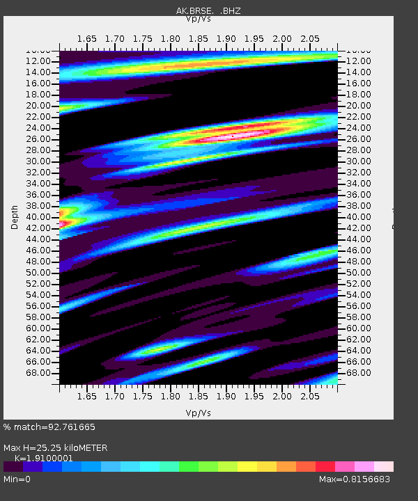
| Estimated Moho Depth: |
25.25 km |
| Estimated Crust Vp/Vs: |
1.91 |
| Assumed Crust Vp: |
6.24 km/s |
| Estimated Crust Vs: |
3.267 km/s |
| Estimated Crust Poisson's Ratio: |
0.31 |
|
| Radial Match: |
92.761665 % |
| Radial Bump: |
400 |
| Transverse Match: |
89.40075 % |
| Transverse Bump: |
400 |
| SOD ConfigId: |
790520 |
| Insert Time: |
2014-09-18 05:47:10.003 +0000 |
| GWidth: |
2.5 |
| Max Bumps: |
400 |
| Tol: |
0.001 |
|

Signal To Noise
| Channel | StoN | STA | LTA |
| AK:BRSE: :BHZ:20140904T05:45:39.568Z | 19.0417 | 1.946463E-6 | 1.0222107E-7 |
| AK:BRSE: :BHN:20140904T05:45:39.568Z | 8.08416 | 5.3047984E-7 | 6.5619666E-8 |
| AK:BRSE: :BHE:20140904T05:45:39.568Z | 2.5410101 | 2.1742463E-7 | 8.5566214E-8 |
| Arrivals |
| Ps | 3.8 SECOND |
| PpPs | 12 SECOND |
| PsPs/PpSs | 15 SECOND |


