You are here: Home > Network List > AK - Alaska Regional Network Stations List
> Station KULT Kultieth River Mtn, AK, USA > Earthquake Result Viewer
KULT Kultieth River Mtn, AK, USA - Earthquake Result Viewer
| Earthquake location: |
Tonga Islands |
| Earthquake latitude/longitude: |
-21.4/-173.3 |
| Earthquake time(UTC): |
2014/09/04 (247) 05:33:46 GMT |
| Earthquake Depth: |
12 km |
| Earthquake Magnitude: |
6.0 MWB |
| Earthquake Catalog/Contributor: |
NEIC PDE/NEIC COMCAT |
|
| Network: |
AK Alaska Regional Network |
| Station: |
KULT Kultieth River Mtn, AK, USA |
| Lat/Lon: |
60.25 N/142.72 W |
| Elevation: |
1006 m |
|
| Distance: |
85.1 deg |
| Az: |
14.735 deg |
| Baz: |
208.374 deg |
| Ray Param: |
0.045027588 |
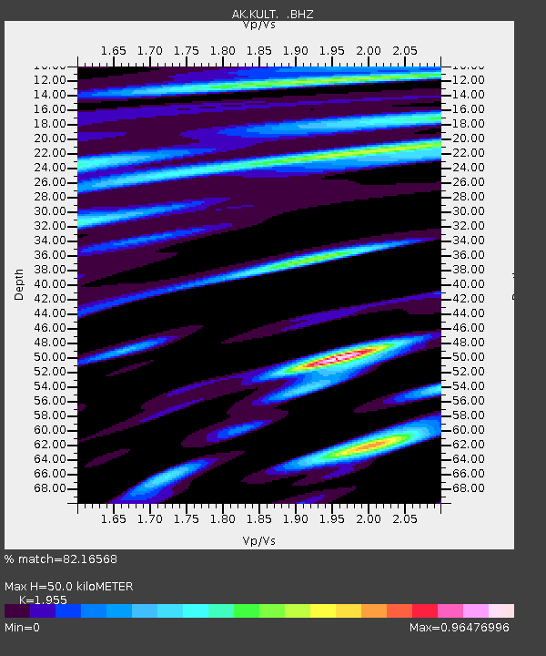
| Estimated Moho Depth: |
50.0 km |
| Estimated Crust Vp/Vs: |
1.96 |
| Assumed Crust Vp: |
6.566 km/s |
| Estimated Crust Vs: |
3.359 km/s |
| Estimated Crust Poisson's Ratio: |
0.32 |
|
| Radial Match: |
82.16568 % |
| Radial Bump: |
400 |
| Transverse Match: |
82.96565 % |
| Transverse Bump: |
400 |
| SOD ConfigId: |
790520 |
| Insert Time: |
2014-09-18 05:48:28.121 +0000 |
| GWidth: |
2.5 |
| Max Bumps: |
400 |
| Tol: |
0.001 |
|

Signal To Noise
| Channel | StoN | STA | LTA |
| AK:KULT: :BHZ:20140904T05:45:50.468025Z | 13.72673 | 1.92176E-6 | 1.4000129E-7 |
| AK:KULT: :BHN:20140904T05:45:50.468025Z | 3.074774 | 5.6333874E-7 | 1.8321305E-7 |
| AK:KULT: :BHE:20140904T05:45:50.468025Z | 1.3041661 | 2.920303E-7 | 2.2392109E-7 |
| Arrivals |
| Ps | 7.4 SECOND |
| PpPs | 22 SECOND |
| PsPs/PpSs | 29 SECOND |


