You are here: Home > Network List > AZ - ANZA Regional Network Stations List
> Station TMSP TMSP, CA, USA > Earthquake Result Viewer
TMSP TMSP, CA, USA - Earthquake Result Viewer
| Earthquake location: |
Tonga Islands |
| Earthquake latitude/longitude: |
-21.4/-173.3 |
| Earthquake time(UTC): |
2014/09/04 (247) 05:33:46 GMT |
| Earthquake Depth: |
12 km |
| Earthquake Magnitude: |
6.0 MWB |
| Earthquake Catalog/Contributor: |
NEIC PDE/NEIC COMCAT |
|
| Network: |
AZ ANZA Regional Network |
| Station: |
TMSP TMSP, CA, USA |
| Lat/Lon: |
33.62 N/116.68 W |
| Elevation: |
2077 m |
|
| Distance: |
76.8 deg |
| Az: |
45.673 deg |
| Baz: |
233.027 deg |
| Ray Param: |
0.05075157 |
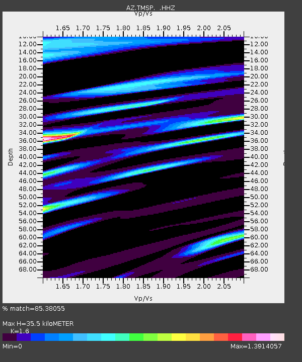
| Estimated Moho Depth: |
35.5 km |
| Estimated Crust Vp/Vs: |
1.60 |
| Assumed Crust Vp: |
6.264 km/s |
| Estimated Crust Vs: |
3.915 km/s |
| Estimated Crust Poisson's Ratio: |
0.18 |
|
| Radial Match: |
85.38055 % |
| Radial Bump: |
400 |
| Transverse Match: |
81.057274 % |
| Transverse Bump: |
400 |
| SOD ConfigId: |
790520 |
| Insert Time: |
2014-09-18 05:54:00.479 +0000 |
| GWidth: |
2.5 |
| Max Bumps: |
400 |
| Tol: |
0.001 |
|

Signal To Noise
| Channel | StoN | STA | LTA |
| AZ:TMSP: :HHZ:20140904T05:45:06.489021Z | 12.60029 | 1.321019E-6 | 1.0484036E-7 |
| AZ:TMSP: :HHN:20140904T05:45:06.489021Z | 2.4185135 | 3.5740686E-7 | 1.4777956E-7 |
| AZ:TMSP: :HHE:20140904T05:45:06.489021Z | 1.6779094 | 2.987076E-7 | 1.7802367E-7 |
| Arrivals |
| Ps | 3.5 SECOND |
| PpPs | 14 SECOND |
| PsPs/PpSs | 18 SECOND |


